

Pass Creek Road is a hidden gem in western Huerfano County. It crosses the Sierra Blanca ridge from Costilla County in the south to the Upper Huerfano River Valley in the north. Along the way it passes through a simply beautiful countryside with some very interesting geology.

Sheep Mountain, from just north of the Sierra Blanca ridge
The mountains to the west of Pass Creek are old, about 1.7 billion years old, part of the Colorado Orogeny upthrust that put Mt. Blanca, California Peak, the Front Range, and most of the Wet Mountains in place. The mountains to the east of Pass Creek are young, about 25 million years old, all part of the igneous intrusion that we call Mt. Mestas, Silver Mountain, Rough Mountain, and the Sheep Mountains. This area was once part of the Grayback Mining District, with most of the mining activity going on in the mountains to the west.

A granite dike runs along the west side of the road in places

The Sangre de Cristo's can sometimes be seen

A wall of Dakota sandstone rising on the east side of the road

Another view of the same Dakota sandstone
Riding through here is actually riding along one of the fault lines that formed the Sangre de Cristo Mountains. The road crosses back and forth through upthrust plates of Dakota sandstone and in between vertical granite walls. The Dakota sandstone testifies to the upward thrusting of the ground: this was horizontal sandstone (ocean bottom) until it was turned up by action along the fault line. The vertical granite walls testify to the flow of molten magma in the cracks in the ground caused by the action along the fault line. Of course, all this activity happened 25 or so million years or more ago. And what we have now...

More Dakota Sandstone

A couple of granite dikes, just before the valley opens out into Malachite
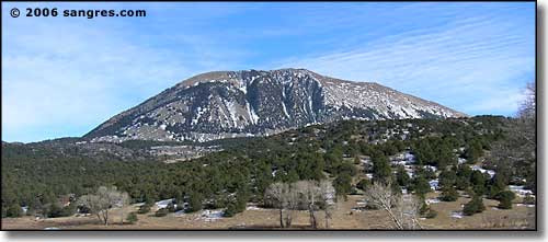
Little Sheep Mountain

The northern Sangre de Cristo's, from south of Malachite

Little Sheep and Sheep Mountains, from the south side of Malachite

The old church in Malachite

Little Sheep, Sheep, Rough Mountain, and Mt. Mestas, from north of Malachite
Malachite was named for the flakes of copper that were found lining the streambeds in the area. The town was originally founded by Tom Sharp when he built a trading post here after the Civil War. In those days, Malachite was on a branch of the Santa Fe Trail that crossed the Sangre de Cristo's and went into the San Luis Valley. It was a busy area until the Santa Fe Trail faded into oblivion with the advent of the railroads. And the railroads, when they finally arrived, went south of here and over La Veta Pass (below the southern end of Pass Creek Road).
