
Nevada Information, Photos and Maps
A Reference and Travel Guide Full of Area Information


In addition to the many natural attractions Nevada offers, a large percentage of visitors to the state come for the Nevada Casinos. With close to 90% of the land in the state owned or managed by Federal and state agencies, the Nevada Legislature was looking for some way to finance state operations other than the imposition of onerous tax structures that would essentially kill all business opportunities in Nevada. So back in 1931, gambling was legalized. As the gambling business didn't really begin to take off until the 1950's, it was not an immediate relief for the state's budget woes. Back in those days there was still some amount of mining going on so taxes on that were pushed up. It helped a couple years later when the federal government allowed the price of an ounce of gold to rise from $20 to $35. Gold mining surged for a few years all across the western states but with the advent of World War II, gold mining was forced out the back door as it was declared "non-essential" to the war effort and those financial and work resources were shifted in other directions. These days, with gold prices running upwards of $1,000 per ounce, even extremely minimal gold deposits are showing a profit. And the huge open pit gold mines of the Carlin Trend are running 24 hours a day, getting that gold out of the ground while prices are still high. Other minerals found in Nevada have also seen recent surges in value, especially the dry lake bed near Silver Peak where a major source of lithium (for cell-phone batteries and such) is mined.
For many years the Federal Government was looking at using the mine shafts beneath Yucca Mountain for the storage of massive amounts of highly radioactive materials being produced by the nation's nuclear energy power plants. There was a lot of protest about this plan, and not just because Yucca Mountain is maybe 50 miles northwest of the metropolitan Las Vegas area. No, the problems stemmed from the presence of major earthquake faults in that area and the possibility that an earthquake could rupture the storage facility and release radioactive materials into the water aquifer that underlies all of southern Nevada. And those materials would eventually be washed further south, polluting the water supplies beneath southern California, too. However, the Federal Government finally came to their senses and shut the program down. Now the search is on for somewhere else to stash that stuff.
Some areas of Nevada were also known for the huge copper mines that operated there. Came a point in their operation where the financial returns didn't justify continued operation of the mines. As the mines shut down, the smelters that served them shut down, too. Then the price of copper rose way up and the minimal returns of copper ore made it plausible to begin operating some of those mines again. However, as much as we might think a domestic supply of copper might make the use of copper less expensive, the mine operators have found that it is cheaper to ship the ore to Japan for processing than to try to re-fit and re-open the smelters here.


A magnificent member of the elk herd found near Ely
| Towns & Places of Nevada |
||
|
NOTE: On many of the pages linked below I try to provide some demographic information. As this information comes from the US Census Bureau, there are a couple of caveats that have to be taken into consideration:
|
||
 From this point you have 2 choices: you can click on a name on the map above, or you can use the list below (and there are more names in the list below than on the map above): | ||
| Amargosa Valley Austin Battle Mountain Beatty Boulder City Caliente Carlin Carson City Crescent Valley Elko Ely Eureka Fallon Fernley Gabbs Gardnerville |
Genoa Gold Hill Goldfield Hawthorne Imlay Henderson Las Vegas Laughlin Lovelock Lund Luning Manhattan McGill Mesquite Mina Minden |
North Las Vegas Pahrump Pioche Reno Round Mountain Ruth Silver Peak Sparks Tonopah Virginia City Walker Lake Wells West Wendover Winnemucca Yerington |
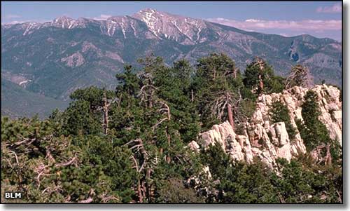
Mt. Stirling Wilderness Study Area
