 |
Unique Natural FeaturesColorado, Utah, Arizona |
|
|
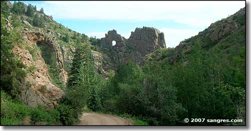
 Window Rock on Shelf Road, on the Gold Belt Loop |
|
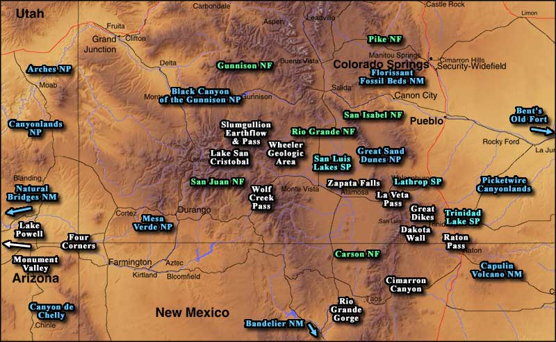
The map below indicates quite a few of the natural wonders and cultural and historic features that are present in southern Colorado and northern New Mexico. As time goes on, I get deeper and deeper into the countryside in my explorations and I do what I need to to earn the "bragging rights" that allow me to expound on all the beautiful and wondrous things that I come across. And there's something about taking my own photos as I do this... Clicking on an active name on the imagemap below will take you to that part of sangres.com. Some of these presentations have photo galleries and maps attached to them, and some will be expanded as I spend more time in each area and explore it for myself. Most of these pages also contain links to the official State and National Park Service and Forest Service websites for those attractions. Some of these pages are simply about elements that my website visitors have enquired about. So many wonders, so little time... This collection of data and photos is by no means comprehensive. This is a large landscape with an abundance of elements that I want to see and touch and explore for myself. Wait a minute... did you hear it? That was the Call of the Wild again. It keeps ringing in my ears and in my head... Gotta get rid of this day job and get on with living my life... not getting any younger, you know... On a regular basis my presentation outgrows this map and I have to replace it with a new one. That means that I'm having fun and getting ready to have more... |
 |
| Just click on an attraction name and you will be taken to that part of sangres.com. Or you can use the list below: |
|
Arches National Park
Black Canyon of the Gunnison National Park Canyonlands National Park Great Sand Dunes National Park Mesa Verde National Park Bandelier National Monument Bent's Old Fort National Historic Site Capulin Volcano National Monument Canyon de Chelly National Monument Natural Bridges National Monument Carson National Forest Gunnison National Forest Pike National Forest Rio Grande National Forest San Isabel National Forest San Juan National Forest
Cimarron Canyon State Park
The Dakota Wall Four Corners Great Dikes of the Spanish Peaks La Veta Pass Lake Powell Lake San Cristobal Lathrop State Park Monument Valley Picketwire Canyonlands Raton Pass Rio Grande Gorge San Luis Lakes State Park Slumgullion Earthflow & Pass Trinidad Lake State Park Wheeler Geologic Area Wolf Creek Pass Zapata Falls |
| Other Features Covered But Not On The Map Or Listed Above: |
|
Abiquiu Lake
Aguilar Hogback Alamosa NWR Angel Peak National Recreation Area Arapaho - Roosevelt National Forest Aztec Ruins National Monument Baca NWR Bishop's Castle Blue Mesa Reservoir Brazos Cliffs Buttes, Plugs and Cones Cochetopa Pass - East Side Cochetopa Pass - West Side Colorado National Monument Cuchara Pass - South Side Cuchara Pass - North Side Dawson Cemetery National Historic Site Eagle Nest Lake State Park Fort Union National Monument Glenwood Canyon Grand Mesa National Forest Greenhorn Mountain National Wilderness Area
Hoosier Pass
Independence Pass John Martin Reservoir Lake Isabel Lake Maloya Loveland Pass Maxwell National Wildlife Refuge Monarch Pass Monte Vista NWR Morrow Point Lake Orilla Verde National Recreation Area Pecos National Historical Park Penitente Canyon Pueblo Lake State Park Santa Fe National Forest Springer Lake Taos Gorge Bridge Taos Pueblo Uncompahgre National Forest White River National Forest Zapata Ranch |
|
From the size of the map and the length of my list, you might see that I'm having a bit of a dilemma: how to organize this data in an easily accessible manner. At the same time, there's so much stuff in this website that I'm never sure if I've got it all on the proper list or map or even if it's all properly linked together. These high-end web editing programs only tell me when I've broken a previously made link, not when I forget to make a new link. And then I look at my bookcase and see the huge backlog of photos, data and maps, just waiting to be processed and added to the site... so why don't I quit the day job and just do this full time... what a great idea! Update 2011: Well... that was a good idea until our wondrous politicians and their greedy banker friends decided to loot America and shift all the proceeds overseas. Now I get phone calls from people in India wanting to know how they can get at whatever money I still have left... Back in 1992 Bill Clinton made his first inaugural speech. In that speech he said "the American Dream is over. Our children and our grand-children are not going to have it as good as we've had it. It's time to pay the bill." Then he presided over the eight years of greatest middle class American prosperity in history. It's like Ronald Reagan's "trickle-down economics" finally worked (beginning many years after that also famous speech). Now we're seeing the truth of that "American Dream is over" speech, also many years after the speech was first uttered. |
|
|
 |
| Index - Arizona - Colorado - Idaho - Montana - Nevada - New Mexico - Utah - Wyoming National Forests - National Parks - Scenic Byways - Ski & Snowboard Areas - BLM Sites Wilderness Areas - National Wildlife Refuges - National Trails - Rural Life Sponsor Sangres.com - About Sangres.com - Privacy Policy - Accessibility |
| Photos courtesy of Sangres.com, CCA ShareAlike 3.0 License. The map is courtesy of Cartesia MapArt Terrain Text Copyright © by Sangres.com. All rights reserved. |