
Canyon de Chelly National Monument


At the base of sheer red cliffs and in canyon wall caves are ruins of Indian villages built between AD 350 and 1300. Canyon de Chelly National Monument offers visitors the chance to learn about Southwestern Indian history from the earliest basketmakers to the Navajo Indians who live and farm here still.
In comparison with the landscape for miles around, the canyon is a veritable paradise. The canyon actually looks like a crack in the surface of the flat plateau. There are no high points visible to attract roving marauders. Indian tribes found the canyon a great place to live because no one knew it was here unless they stumbled across it while journeying across the plateau. Even today, as you drive into the area, you find yourself wondering what all the hubbub is about: you don't know the canyon is there until you are looking out over its edge.
Canyon de Chelly is comprised of 83,840 acres encompassing the canyon floors and rims of del Muerto, de Chelly and Monument Canyons. This is all Navajo Tribal Trust Land set aside to preserve the artifacts left behind by ancient indigenous peoples. Canyon de Chelly National Monument is unique in that members of the Navajo Nation still live in the canyons. Because of this, access to the canyon floor is restricted everywhere except along the White House Ruin trail.
Defending the canyon was easy: just hold your position at the end where the river flows out. Almost everywhere else is defended by sheer cliffs rising several hundred feet from the bottom. And with the river and vegetation in the bottom of the canyon, life was pretty good.
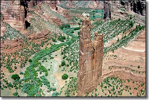
Spider Woman Rock


The canyon was well populated up into the late 1200's. About that time came a 50 year drought. The same drought spelled doom for the inhabitants of Chaco Canyon and eventually for the people of the Aztec and Salmon ruins and of Mesa Verde. It was after this drought, after everyone except the Hopi had left, that the Navajo first arrived in the area (the Navajo and Apache are probably the most recent of the Native American arrivals in the Southwest, and they didn't arrive much before the Spaniards first appeared on the scene).
Most visitors to the canyon content themselves with a drive around the rim, stopping to look down in here and there. Guided Jeep tours along the river bottom are offered on a limited basis by a Navajo-owned concession. There are many ruins and places of religious importance in this canyon, including Spider Woman Rock, named for a Hopi deity.

Navajo Fortress


Slide House Ruins (just to the right of the rock slide)


White House Ruins

Canyon de Chelly National Monument area map
