 |
Tonopah, Nevada |
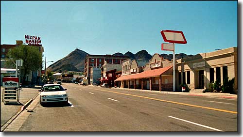 Downtown Tonopah, Nevada |
|
Tonopah is a census designated place that is also the county seat of Nye County. Tonopah bills itself as the "Queen of the Silver Camps." Supposedly, gold and silver ore were discovered in this area by a prospector named Jim Butler. One of his burros had wandered off during the night and he found it the next morning near a large rock outcropping. He picked up a rock to throw at the burro and noticed the rock was really heavy. So began the second richest silver strike in Nevada history. Mines popped up all over the place but the ore body ran out before too long and the get-rich-quick folks were soon gone. However, the business was so hot-and-heavy that 1903 saw a major riot happen in Tonopah against Chinese workers in the area. That riot led to a boycott of American-made goods in China. About 30 miles to the southeast of Tonopah is the Tonopah Test Range (also known as Area 52 - not the famous Area 51 of the alien conspiracy theorists, but close). This is at the northern edge of the Nellis Air Force Bombing & Gunnery Range and is inaccessible to the public. The Tonopah Test Range is where the F-117 Stealth fighters were first operated, from 1982 through 1989. Tonopah Test Range is also where the Red Eagles were based (the Red Eagles were a squadron of US Air Force pilots who flew Russian MiG fighter aircraft from 1979 to 1988, learning what the aircraft were capable of and how to fly against them). The Tonopah Test Range has been administered for most of its life by Sandia National Laboratory. |
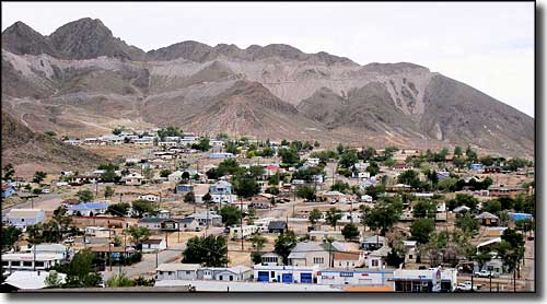 Looking across Tonopah 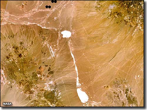 Satellite view of the Tonopah Test Range area |
| Fast Facts about Tonopah, Nevada |
|
Tonopah, Nye County, NV 89049
Founded: 1900 Elevation: 6,047' Latitude: 38.0691°N Longitude: 117.2305°W Resident Racial Breakdown: White Non-Hispanic: 91.4% Hispanic: 7.8% Native American: 0.4% Two or More Races: 0.5% Education: High School or Higher: 81.2% Bachelor's Degree or Higher: 9.0% Graduate or Professional Degree: 3.2% 2009 Estimates: Population: 3,517 Males: 1,828 Females: 1,689 Median Resident Age: 38.7 Years Estimated Median Household Income: $50,400 Estimated Median Home Value: $77,500 2011 Cost of Living Index for Tonopah: 88.3 Major Industries: Mining, Lodging & Food Services, Construction, Entertainment & Recreation, Government, Educational Services, Transportation Equipment, Health Care, Waste Management Services, Professional Services, Finance & Insurance Services Unemployed: 17.1% |
|
|
Nye County Related Pages
Amargosa Valley - Beatty - Gabbs - Manhattan - Pahrump - Round Mountain - Nye County
Berlin-Ichthyosaur State Park - Belmont Courthouse State Historic Park Extraterrestrial Highway - Lunar Crater Back Country Byway Other Nye County Related Pages
Humboldt-Toiyabe National Forest - Alta Toquima Wilderness - Arc Dome Wilderness
Ash Meadows NWR - Currant Mountain Wilderness - Grant Range Wilderness Quinn Canyon Wilderness - Table Mountain Wilderness Nevada Pages |
 |
| Index - Arizona - Colorado - Idaho - Montana - Nevada - New Mexico - Utah - Wyoming National Forests - National Parks - Scenic Byways - Ski & Snowboard Areas - BLM Sites Wilderness Areas - National Wildlife Refuges - National Trails - Rural Life Advertise With Us - About This Site - Privacy Policy |
| Upper photo of Tonopah, Nevada courtesy of Cooper.ch, CCA ShareAlike 3.0 License. Satellite photo of Tonopah Test Range courtesy of NASA. Text Copyright © by Sangres.com. All rights reserved. |