 |
Henderson, Nevada |
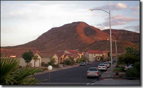 Black Mountain (in the North McCullough Range) is almost surrounded by Henderson |
Henderson's first "business" was the Basic Magnesium Plant, a factory that supplied the U.S. War Department with magnesium for airplane engines, frames and incendiary munitions casings during World War II. At its peak, the plant employed some 14,000 workers but when the plant was closed in 1946, nearly all of them left the area. The War Asset Administration went so far as to offer Henderson for sale as a "war surplus property" early in 1947. The entire Nevada Legislature spent a weekend in Henderson that spring, looking to see if it was worth it to reopen the manufacturing plant as a state-supported business. Within days, the legislature approved a bill that gave authority to purchase the industrial plants to the Colorado River Commission of Nevada. On March 27, 1947, Governor Vail Pittman signed the bill, saving Henderson from being "war surplus." In 1988, there were multiple explosions at the PEPCON rocket fuel factory in town. Two people were killed as some of the explosions measured more than 3.0 on the Richter earthquake scale. I left my hotel room in Henderson that morning just before the first explosion took place (I was headed for Santa Fe, New Mexico and had spent most of the previous night in the gaming dens of downtown Las Vegas). I crossed Hoover Dam and went a few more miles south before turning in to a side road that gave me some great views over Black Canyon. Looking back toward Henderson there was a mushroom cloud rising high in the atmosphere. My first thought: are we being nuked? I got back in my vehicle and headed for Kingman, and didn't see another vehicle on the road the whole distance. As I came into Kingman I found the Arizona Highway Patrol had blocked off the highway and weren't letting anyone go north. They told me about the explosions in Henderson. It was that singular event that changed the course of Henderson from the industrial city it was into the office and residential city it is today. The original townsite covered about 13 square miles. Today, Henderson has grown to cover almost 80 square miles with massive residential housing developments and an ever-increasing number of shopping complexes, movie theater complexes, casino resorts and restaurants. Henderson is now the second largest city in Nevada (after Las Vegas). Until the recent (2009) mortgage crisis and financial collapse, Henderson was one of the fastest growing cities in America. |
| Fast Facts about Henderson, Nevada |
|
Henderson, Clark County, NV
Zip Codes: 89011, 89012, 89014-89016, 89052, 89053 Incorporated: April 16, 1953 Elevation: 1,867' Latitude: 36.0292°N Longitude: 115.0253°W Resident Racial Breakdown: White Non-Hispanic: 78.2% Hispanic: 10.7% African-American: 3.8% Native American: 1.4% Other: 3.2% Two or More Races: 3.5% Filipino: 1.7% Chinese: 0.5% Japanese: 0.5% Education: High School or Higher: 88.5% Bachelor's Degree or Higher: 23.7% Graduate or Professional Degree: 7.9% 2009 Estimates: Population: 256,445 Males: 127,214 Females: 129,231 Median Resident Age: 35.9 Years Estimated Median Household Income: $65,757 Estimated Median Home Value: $324,300 Population Density: 3,218 People per Square Mile 2009 Cost of Living Index for Henderson: 92.9 Major Industries: Lodging & Food Services, Construction, Entertainment & Recreation, Health Care, Educational Services, Professional Services, Finance & Insurance Services, Government, Waste Management Services Unemployed: 4.7% |
|
|
Clark County Related Pages
Boulder City - Las Vegas - Laughlin
Mesquite - North Las Vegas - Clark County Old Las Vegas Mormon State Historic Park - Valley of Fire State Park - Big Bend of the Colorado Recreation Area Spring Mountain Ranch State Park - Las Vegas Ski & Snowboard Resort Other Clark County Related Pages
Lake Mead National Recreation Area - Humboldt-Toiyabe National Forest
Red Rock Canyon Scenic Byway - Valley of Fire Scenic Byway Mt. Charleston Scenic Byway - Bitter Springs Back County Byway Gold Butte Back Country Byway - Desert National Wildlife Refuge Black Canyon of the Colorado Wilderness - Bridge Canyon Wilderness Eldorado Mountains Wilderness - Ireteba Peaks Wilderness- Jimbilnan Wilderness La Madre Mountain Wilderness - Mount Charleston Wilderness - Nellis Wash Wilderness Pinto Valley Wilderness - Rainbow Mountain Wilderness - Spirit Mountain Wilderness Jumbo Springs Wilderness - Lime Canyon Wilderness - Wee Thump Wilderness North McCullough Mountains Wilderness - South McCullough Mountains Wilderness Nevada Pages |
 |
| Index - Arizona - Colorado - Idaho - Montana - Nevada - New Mexico - Utah - Wyoming National Forests - National Parks - Scenic Byways - Ski & Snowboard Areas - BLM Sites Wilderness Areas - National Wildlife Refuges - National Trails - Rural Life Advertise With Us - About This Site - Privacy Policy |
| Upper photo courtesy of Wikipedia userid Spitwater, CCA ShareAlike 3.0 License. Text Copyright © by Sangres.com. All rights reserved. |