 |
Ponderosa Pine Scenic Byway |
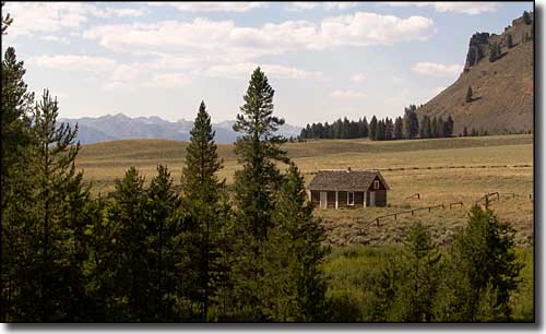 An old ranger station in Boise National Forest along the Ponderosa Pine Scenic Byway |
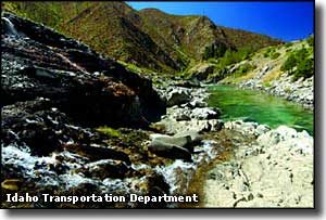
The Ponderosa Pine Scenic Byway leaves the Boise area and heads north on Idaho Route 21. 131 miles later it terminates in Stanley. In between you pass by Lucky Peak State Park, then Idaho City. Back in the days of the big gold strikes, Idaho City was the largest settlement in Idaho. Then the gold deposits ran out, most of the miners left and today we have a beautiful historic site in the heart of Boise National Forest. Continuing on you'll come to Lowman and the junction with the Wildllife Canyon Scenic Byway along the South Fork of the Payette River. The Ponderosa Pine Scenic Byway then takes over the canyon of the South Fork and heads east, passing below the heights of the Sawtooth Wilderness to the south and the Frank Church-River of No Return Wilderness to the north before reaching its end in Stanley at the junction with the Salmon River Scenic Byway and the Sawtooth Scenic Byway. Idaho Highway 21 leaves Boise headed southeast, then turns northeast near Lucky Peak Reservoir and passes Lucky Peak State Park before heading up into the hills toward Idaho City. Idaho City was founded after a large placer gold strike in 1862. For several years it was the largest city in the Northwest with more than 250 businesses in town and the largest Chinatown outside of San Francisco. Nearly 20 of the buildings still standing in town are listed in the National Register of Historic Places. For the full story, check out the Boise Basin Museum in downtown. There's also several places in town where you can try your hand at panning for gold in the streams. Also in the Idaho City area is the Boise Basin Loop, a route through some of the old gold mining areas up in the hills above Idaho City. The Boise Basin was primarily a placer deposit, which was a completely different form of mining (as opposed to hard rock mining). In the first 5 years of working over the soils in the area, more than $100 million (in 1860's money) was removed from the ground. A lot of this money was used to support the Union Treasury during the Civil War. Today, the Loop route passes by many of the historic homes and cemeteries left in the area. Idaho City is also at the center of the Idaho City Area Trail System, a network of more than 60 miles of year-round recreational trails in the Boise National Forest. The Ponderosa Pine Scenic Byway continues climbing the grade north of Idaho City until it tops Mores Creek Summit at 6,118' before beginning the drop into the canyon of the South Fork of the Payette. Next you'll come to Lowman, an area with full services and a few nice campgrounds, like the one at Kirkham Hot Springs (140°F mineral springs, open to the public). If you're driving this road in the winter, somewhere between Kirkham Hot Springs and Banner Summit (7,056') you may come to a road closure where you can either turn around and go back down the hill or wait until late spring for the snow to melt off. It's in this area that you start to really get views of the Sawtooth Mountains and Wilderness. North of Banner Summit is where views of the Frank Church-River of No Return Wilderness start to come into play. Beyond Banner Summit you'll be rounding the northern end of the Sawtooths and then heading southeast into Stanley. Stanley is in the valley of the Salmon River with the Sawtooth Range to the west and the White Cloud Peaks to the east. This is the heart of the Sawtooth National Recreation Area. Near the northern terminus of the Ponderosa Pine Scenic Byway is Stanley Lake in the Sawtooth National Recreation Area. Located around Stanley Lake are three campgrounds and several developed picnic areas. There are swim beaches and boat ramps on the lake and several hiking trails that lead into the depths of the Sawtooth Mountains and Sawtooth Wilderness. For folks looking for a beautiful day loop drive through some of the finest countryside in Idaho, take a look at driving up the Ponderosa Pine Scenic Byway to Lowman, then turn west on the Wildlife Canyon Scenic Byway and go to the end of that at the Payette River. Then turn and head south back to Boise over the Payette River Scenic Byway. |
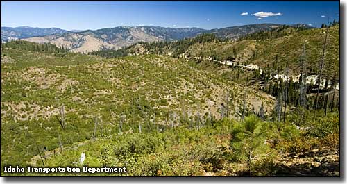 Banner Ridge, in the Idaho City Area Trail System 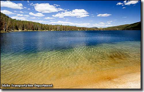 Stanley Lake, near the foot of the Sawtooth Mountains 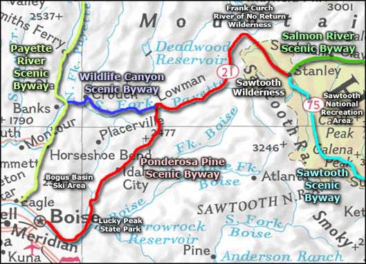 Ponderosa Pine Scenic Byway area map |
|
|
Ponderosa Pine Scenic Byway Related Pages
Salmon River Scenic Byway - Sawtooth Scenic Byway - Wildlife Canyon Scenic Byway
Boise National Forest - Sawtooth National Forest - Lucky Peak State Park Sawtooth Wilderness - Frank Church-River of No Return Wilderness Bogus Basin Ski Area - Payette River Scenic Byway Idaho Pages |
 |
| Index - Arizona - Colorado - Idaho - Montana - Nevada - New Mexico - Utah - Wyoming National Forests - National Parks - Scenic Byways - Ski & Snowboard Areas - BLM Sites Wilderness Areas - National Wildlife Refuges - National Trails - Rural Life Advertise With Us - About This Site - Privacy Policy |
| Upper photo courtesy of J. Crane, Byways.org Other photos courtesy of Idaho Transportation Department. Area map courtesy of National Geographic Topo! Text Copyright © by Sangres.com. All rights reserved. |