Duncan, Arizona

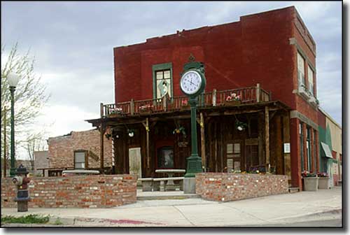
On Spezia Square in Duncan, Arizona

Straddling the Gila River near the Arizona-New Mexico state line, Duncan has been destroyed twice by floods and once by fire since the town was founded in 1883. One story says 2 brothers, J. Duncan Smith and Sheriff Guthrie Smith, sold their property to the Arizona & New Mexico Railroad, built in 1883 to connect Clifton with the main Southern Pacific Railroad line near Lordsburg, New Mexico. The railroad built a stop on their former property and named it for Duncan Smith. Another story talks of 2 brothers named Duncan who were killed by Apaches in the area in 1885. A third story attributes the name to James Duncan, a director of the Arizona Copper Company. Anyway, across the river from Duncan was the settlement of Purdy. When the train stop was established in Duncan, the Purdy post office was relocated to Duncan and renamed.
The hills around Duncan used to harbor zinc and copper mines. The railroad stop made Duncan a marketing center for farm produce and a shipping point for ore and cattle. The largest fire agate field in America is in the Black Hills Rockhounding Area north of Duncan (reached via the Black Hills Back Country Byway).
While the Duncan area is now home mostly to Mormons, ranchers, farmers and miners, this area is world-renowned as a natural repository of historic and pre-historic Native American artifacts. These days, a large part of the downtown area of Duncan has been shuttered and boarded up, although the Duncan Pride Society has been working hard to clean up and dress up the old area.
Supreme Court Justice Sandra Day O'Connor grew up on the Lazy B Ranch, just outside of Duncan.
Latitude: 32.7258°N
Longitude: 109.0977°W
Founded: 1883; Incorporated: 1938
Elevation: 3,655'
Education:
High School or Higher: 73.5%
Bachelor's Degree or Higher: 9.8%
Graduate or Professional Degree: 4.6%
2011 Cost of Living Index for Duncan: 81.5
Median Resident Age: 28.4 Years
Estimated Median Household Income: $32,700
Estimated Median Home Value: $52,700
Population Density: 300 People per Square Mile
Major Industries:
Mining, Construction, Educational Services, Health Care, Rail Transportation, Government, Waste Management Services, Retail Services, Lodging & Food Services, Agriculture
Unemployed (March 2011): 9.1%
2010 Population Demographics
| Total Population | 696 |
| Males | 359 |
| Females | 337 |
| Population by Age | |
| Under 18 | 182 |
| 18 & over | 514 |
| 20-24 | 31 |
| 25-34 | 56 |
| 35-49 | 150 |
| 50-64 | 155 |
| 65 & over | 109 |
| Population by Ethnicity | |
| Hispanic or Latino | 235 |
| Non Hispanic or Latino | 461 |
| Population by Race | |
| White | 563 |
| African-American | 8 |
| Asian | 0 |
| Native American | 12 |
| Hawaiian or Pacific Islander | 1 |
| Other | 87 |
| Two or more | 25 |
