 |
Anaconda-Pintler Wilderness |
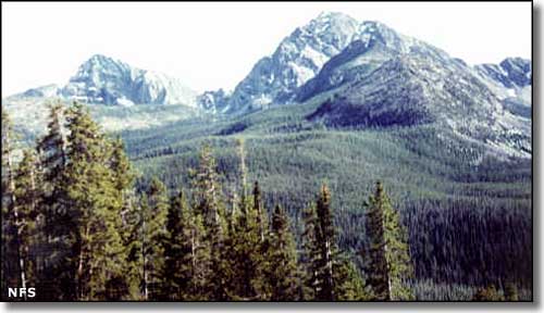 In the Anaconda-Pintler Wilderness |
|
The 158,615 acres of the Anaconda-Pintler Wilderness straddle the Continental Divide as it follows the crest of the Anaconda Mountain Range. This is a heavily glaciated landscape of high, rugged peaks, sharp cirques, wide U-shaped valleys, and layers of glacial moraines. Runoff from the snowfields above timberline feeds into crystal clear streams and sparkling alpine lakes before heading further down the hill over cascades of boulder-filled waterfalls. The lakes tend to be frozen over until mid-July, but once they're open you'll find excellent fishing for 4 species of trout and 3 species of char, plus arctic grayling and Rocky Mountain whitefish. It also helps that Montana Game and Fish keeps the lakes well-stocked. The headwaters of Rock Creek are classed as a Blue Ribbon trout stream, then there's the upper branches of the Big Hole and Bitterroot Rivers... Elevations range from a low of about 5,100' to the summit of West Goat Peak at 10,793'. The usual big game suspects are prowling in these woods: deer, elk, moose, mountain lion, black bear and mountain goat. At the lower end of the hill you'll find sagebrush and willow flats that quickly rise to fir, pine and spruce that also quickly give way to the pine, fir, larch and aspen that run up to treeline. Above treeline is just bare rock and talus with a bit of lichen thrown in. A 45-mile chunk of the Continental Divide National Scenic Trail follows along the crest of the Anaconda-Pintler Wilderness. In spite of the hundreds of miles of other trails in this beautiful wilderness, you'll find most of the human visitors to the Anaconda-Pintler Wilderness on this one trail. Easiest access to the Anaconda-Pintler Wilderness is via trailheads at Moose Lake and Lutz Creek on the north side and trailheads at Pintler Lake on the south side. There's also an excellent trail from the west that follows the East Fork of the Bitterroot River right up under West Pintler Peak. The Mussigbrod and other, smaller forest fires of 2000 caused serious damage to a lot of the forest north of Pintler Pass, including the area around Johnson Lake. |
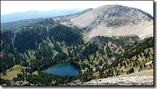 Oreamnos Lake and West Pintler Peak, from the ridge near East Pintler Peak 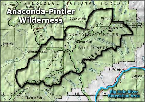 Anaconda-Pintler Wilderness area map |
|
|
 |
| Index - Arizona - Colorado - Idaho - Montana - Nevada - New Mexico - Utah - Wyoming National Forests - National Parks - Scenic Byways - Ski & Snowboard Areas - BLM Sites Wilderness Areas - National Wildlife Refuges - National Trails - Rural Life Advertise With Us - About This Site - Privacy Policy |
| Upper photo of the Anaconda-Pintler Wilderness is courtesy of the National Forest Service. Lower photo of the Anaconda-Pintler Wilderness courtesy of G. Thomas. Map courtesy of National Geographic Topo! Text Copyright © by Sangres.com. All rights reserved. |