 |
Pioneer Mountains Scenic Byway |
 Along the Pioneer Mountains Scenic Byway |
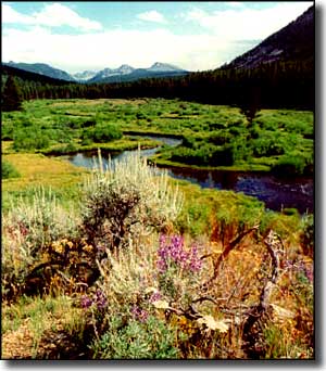
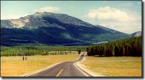
The Pioneer Mountains Scenic Byway is a partly paved, 49-mile drive up and over the crest of the Pioneer Mountains in southwestern Montana. In the old days, this was homesteaders' and miners' countryside. The mines around here turned up some silver, but when the federal government dropped silver in favor of the gold standard, all that value went out the window. Silver mining had to wait until 1903 for the price of silver to rise enough to make the mines profitable. And even then, they were profitable only into the 1930's when the Great Depression reduced silver prices below what it cost to produce again. If you want, though, above Elkhorn Hot Springs is a road to the southeast that will take you almost to the ghost town at Coolidge and the old Elkhorn silver mine (the road ends at a parking lot and leaves you with a 1/4 mile hike to the townsite). From Wise River, the route heads south up the valley of the Wise River to cross the divide at 7,800' before dropping down the valley of Grasshopper Creek through Elkhorn Hot Springs and into Polaris. Along the way there are several interpretive sites and historical markers that offer information and tales from the "good old days," back when the dry summers, harsh winters, flash floods and clouds of flying insects made many a homesteader's life interesting... This journey up the valley of the Wise River starts off through ranch land on a dry bench, then enters the Beaverhead-Deerlodge National Forest after about 4.5 miles. Once in the forest, the valley gets much narrower, and the side slopes much steeper. The first 20 miles out of Wise River are mostly alongside the Wise River, with several Forest Service campgrounds and hiking trails along the way. At about 21 miles south of Wise River is the junction with Forest Road #2465, the road that leads 5 miles southeast to Coolidge. Just beyond that road junction, the route starts the climb up and out of the Wise River Valley. Another 3 miles and you'll be on a high plateau with big meadows and parks just below treeline. This is the area where you might come across some deer and/or some elk, usually around sunrise or sunset. A little bit further and you'll come to Crystal Park. Crystal Park is a designated site where you can dig your own amethyst crystals out of the ground, and in the summer, a lot of people do. There's a parking area there with picnic tables and restrooms. The road rises for a little bit beyond Crystal Park and then reaches Price Creek. You'll know you're there because that's where the pavement ends and the descent on gravel into the Grasshopper Valley begins. The road narrows (to about 1.5 lanes wide) and follows the contours of the hill for 5.8 miles down to Elkhorn Hot Springs. Elkhorn Hot Springs is a private resort with a small pool, rustic cabins and a cafe, still inside the boundaries of the national forest. Another mile-or-so down the hill brings you to the entrance to Maverick Mountain Ski Area, then the valley starts to open up and the last 4 miles into Polaris are across wide open countryside. Polaris has a post office, a bar and pavement again, and that's about it. It's another 7 miles across a dry bench with big pastures and lots of grazing cattle to get to County Road 278. Go west and you go to Jackson, then Wisdom. Go east and you go to Dillon on the I-15. In the winter you'll find miles and miles of snowmobile trails but the major part of the byway will be unplowed between Wise River and Elkhorn Hot Springs. If you come in through Polaris in the winter, you could also enjoy a day on the ski slopes at Maverick Mountain. |
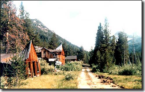 The ghost town at Coolidge 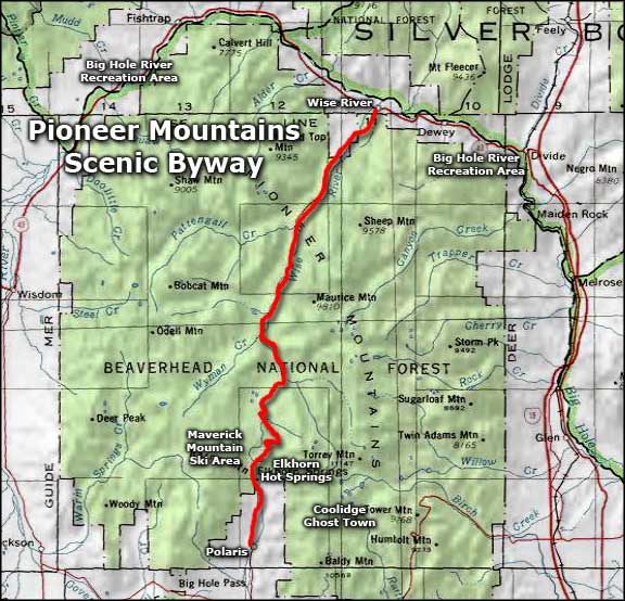 Area map of the Pioneer Mountains Scenic Byway |
|
|
 |
| Index - Arizona - Colorado - Idaho - Montana - Nevada - New Mexico - Utah - Wyoming National Forests - National Parks - Scenic Byways - Ski & Snowboard Areas - BLM Sites Wilderness Areas - National Wildlife Refuges - National Trails - Rural Life Advertise With Us - About This Site - Privacy Policy |
| Photos of the Pioneer Mountains Scenic Byway and Upper Wise River Valley courtesy of Jim Hughes. Photo of Coolidge courtesy of Fred Bridenstine. Map courtesy of National Geographic Topo! Text Copyright © by Sangres.com. All rights reserved. |