
Capitol Reef National Park
Along Highway 24

The first time I went through Capitol Reef National Park, well... it was only a National Monument back then. And all the back roads were little more than prospectors' jeep trails (from the days of uranium prospecting). But even as a 13-year-old, I still remember being impressed by the sheer grandeur of the rock formations that I could see as we made our way slowly along Highway 24 over to Hanksville (we were coming from Bryce Canyon National Park and on our way to Green River).
That was 40-some years ago. Things have changed greatly since then. Now you can actually drive the roads through Capitol Reef in a normal passenger car (you're still going to want some road clearance in some areas of the park). Since the National Park designation, things like interpretive signage, hiking trails and viewpoints/overlooks have been established.
I was last at Capitol Reef in 1991 while touring some friends from New York City around the area. It was a hot summer day and they lasted all of 15 minutes before they required that I take them to Green River where we had a pre-arranged appointment with a swimming pool (what is it with heart-of-the-city folks that they just don't like natural, un-messed-with flowing water for swimming purposes?)
Anyway, it's carved in stone in my agenda to get back to Capitol Reef in the summer of 2011 and spend some time, get some photos, enjoy some of the finest in Utah back-country... Meanwhile, I have some photos (in the public domain) to show here, photos that I found on various National Park Service and USGS websites (that was fun: the photos are great, the programmers were good, but having to read the source code to find my way out of endless repeating loops and into the actual image indexes to get what I got...)
So then, the famous Waterpocket Fold in Strike Valley: probably the single most defining feature of Capitol Reef National Park. This classic monocline is a nearly 100-mile long warp in the Earth's crust that has been exposed to the surface by erosion only within the last 15-20 million years. One side is very steep with a series of parallel vertical layers exposed in an area of otherwise nearly horizontal strata. The Fold was first formed maybe 65 million years ago when the Laramide Orogeny (the same mountain building action that created the Ancestral Rockies in Colorado) reactivated an ancient buried fault. In this "reactivation," the rock layers west of the fault were uplifted more than 7,000 feet above the same rock layers east of the fault. What is now exposed to the eye records a geological history nearly 200 million years in the making.

Golden Throne

In Hall's Creek Valley

Along the Notom-Bullfrog Road

Domes of Navajo Sandstone to the west along the crest of Capitol Reef, from Notom-Bullfrog Road

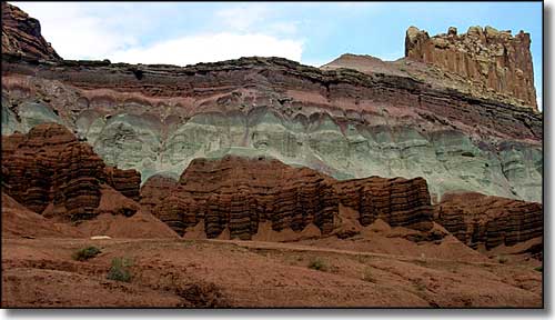
"The Castle"

In the famous Waterpocket Fold

Aerial view of Waterpocket Fold
