 |
Mormon Pioneer National Historic Trail |
|
|
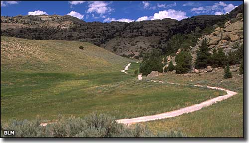 A section of the Mormon Pioneer National Historic Trail in central Wyoming |
|
1846 was a landmark year in the American West: the beginning of the Mexican War, the experiences of the Donner-Reed party in the Sierra Nevada Mountains of California and the beginning of probably the best orchestrated mass emigration in American history. This mass emigration was carried out by members of the Church of Jesus Christ of Latter Day Saints (the Mormons). The Mormon Church was founded by its prophet, Joseph Smith, in Fayette, New York in 1830 but antagonism, harrassment and persecution forced the the church to move its headquarters several times before the church leaders finally decided to move the entire membership west of the Rocky Mountains. The church had grown rapidly from 1830 to 1845, so rapidly that controversy, hostility and fear grew just as quickly around them. Their financial success, their practice of polygamy, their following (and teaching) of doctrines outside mainstream Christianity, their large and well-armed private militia and their tendency to mix church and state all led to escalating hostilities. It was on June 24, 1844 that Joseph Smith and his brother Hyrum were killed by an angry mob while both were jailed in Carthage, Illinois (just east of then church headquarters in Nauvoo). Then more than 200 Mormon homes and farm buildings outside Nauvoo were burned in September 1845. At that point, Brigham Young and other church leaders decided to take action on something they had been discussing since 1842: moving the entire church and congregation west. Previously they had discussed going to Oregon, California or Texas but when they obtained John C. Fremont's map and report of his explorations around the Great Salt Lake of Utah, that became their primary destination. With fears of governmental and military intervention in their affairs growing and with the revocation of the city charter of Nauvoo, they were forced to leave Nauvoo in the dead of winter: February 4, 1846. The first segment of the journey took them 265 miles across Iowa to the Missouri River, following Indian trails and primitive territorial roads. They arrived at the Missouri 4 months later on June 14, 1846. With their lack of supplies and experience, coupled with heavy rains and their general unpreparedness, the group was forced to invent and implement methods and learn skills designed to move large populations of people and their materials cross country. They did establish semi-permanent camps along the way to aid and assist other Mormons in their future travels westward. It was during this first part of the journey that they learned to divide themselves into companies of 100s, 50s and 10s. That June, some of them stayed on the east bank of the Missouri and built the community of Kanesville (later to become Council Bluffs). Others crossed the river and built Winter Quarters (later to become North Omaha). Winter that year was horrible and many people starved and froze to death in Winter Quarters and Kanesville (apparently, cholera was also a big problem in the cramped quarters). The majority of the Mormons in this group started departing from Winter Quarters on April 5, 1847. The lead pioneer group was composed of 143 men, 3 women and 2 young boys with 93 horses, 66 oxen, 52 mules, 19 cows, 72 wagons, 17 dogs and some chickens. This was a hand-picked group that was further divided into 2 companies of 100s, with 50s and 10s. They were much better organized with better provisioning and started out when trail conditions were optimal. The details of their organization also included instructions for devotional practices and camp behavior to be followed on their journey. This first pioneer group reached the Valley of the Great Salt Lake on July 24, 1847. |
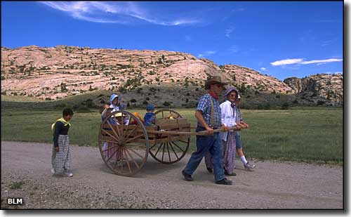 Many Mormon emigrants came west using handcarts like this one to carry their possessions |
|
From Winter Quarters they headed for Fort Kearny and met up with the main route of the Oregon Trail. They traveled along that route to Fort Bridger where they struck out southwest and began the hardest part of their journey: that last 116 miles into the Great Salt Lake area. Two trails had already been blazed through those mountains and the Mormons chose to follow the year-old faint traces left by the Donner-Reed party on their ill-fated journey through the region. This part of the journey was through narrow, willow-choked canyons and over rocky and tree-covered slopes through the Wasatch Mountains. Progress was so slow that it took them 14 days to reach the valley floor. As soon as they arrived, they began plowing fields and planting late crops. They platted streets and built temporary shelters in preparation for the next winter. Other Mormons followed their trail west from Winter Quarters and people were arriving all through the summer and fall. By first snow, about 1,650 people were resident in the valley. Brigham Young and many other members of that first pioneer party had left shortly after seeing that everything was moving forward as planned, and headed back to Winter Quarters to spend the winter with their families while preparing for the next wave of settlers to head for what was soon to be the State of Deseret. Over the next 20 years about 70,000 Mormons from all over the world made the journey to the Valley of the Great Salt Lake, many by wagons and handcarts. The long term Mormon migration was unique in that they used two-wheel handcarts propelled by emigrants (rather than draft animals) to bring many of their European converts to the Salt Lake Valley between 1856 and 1860. 10 companies of travelers used the handcarts but only 2 companies ran into any real trouble along the way. Those 2 companies departed from Winter Quarters in August 1856, kinda late to be starting out on a journey like that. They ran into severe winter weather just west of Fort Casper and several hundred of them froze to death before rescue parties could get there. The opening of the transcontinental railroad in 1869 finally ended most of that overland wagon traffic. Today's Mormon Pioneer National Historic Trail was designated by Congress on November 10, 1978 and is managed as a cooperative effort among the National Park Service, the Bureau of Land Management, the U.S. Forest Service, trail associations, state and local agencies and many private landowners. The route is almost 1,300 miles long and contains about 822 miles on private land, 264 miles on federally-managed land and another 214 miles on land owned by states and local municipalities. |
|
|

|
| Index - Arizona - Colorado - Idaho - Montana - Nevada - New Mexico - Utah - Wyoming National Forests - National Parks - Scenic Byways - Ski & Snowboard Areas - BLM Sites Wilderness Areas - National Wildlife Refuges - National Trails - Rural Life Advertise With Us - About This Site - Privacy Policy |
| Map of the Mormon Pioneer National Historic Trail courtesy of the National Park Service and Bureau of Land Management. Photos courtesy of the Bureau of Land Management. Text Copyright © by Sangres.com. All rights reserved. |