 |
|
|
Salmon-Challis National Forest Campgrounds
|
|
|
|
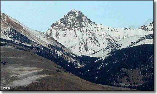
Leatherman Peak, Salmon-Challis National Forest
|
|
|
"I never knew a man who felt self-important
in the morning after spending the night in the open on an Idaho mountainside
under a star studded summer sky. Save some time in your lives for the
outdoors, where you can be witness to the wonders of God." Frank Church, former U.S. Senator from Idaho
Leadore Ranger District
Leadore Ranger District manages and maintains 9 developed camping areas
that open around May 15 and close October 15 (as weather permits). There
are also two BLM (Bureau of Land Management) campgrounds in the Lemhi
Valley. Hunting, fishing, hiking, camping and horseback riding are all
popular activities in our area.
Campground Information:
All campgrounds on the Leadore District are limited to a 14 day stay.
The Meadow Lake Campground is the only fee campground. Facilities include
drinking water, tables and outhouses at most campgrounds. Pets must be
on a leash in campgrounds.
Most other campgrounds in the Salmon-Challis National Forest have a 16-day stay limit.
|
 |
 |
|
 |
 |
 |
 |
 |
 |
 |
 |
 |
| Bear Valley (lower) Equestrian |
- |
6 |
X |
X |
X |
X |
7 |
X |
7 |
- |
- |
| Bear Valley (upper) Trailhead |
- |
1 |
X |
X |
- |
X |
1 |
X |
1 |
- |
- |
| Hawley Creek (lower) |
- |
4 |
- |
X |
- |
X |
3 |
X |
3 |
- |
- |
| Hawley Creek (upper) |
- |
2 |
X |
X |
- |
X |
1 |
X |
2 |
- |
- |
| Big Eightmile Creek |
- |
10 |
X |
X |
- |
X |
10 |
X |
10 |
- |
- |
| Meadow Lake |
X |
18 |
X |
X |
- |
X |
18 |
X |
18 |
 |
X |
| Reservoir Creek |
- |
2 |
- |
X |
- |
X |
1 |
X |
1 |
- |
- |
| Timber Creek Reservoir (lower) |
- |
2 |
- |
X |
- |
X |
1 |
X |
2 |
- |
- |
| Timber Creek Reservoir (upper) |
- |
5 |
- |
X |
- |
X |
4 |
X |
X |
|
- |
| Campground: |
Elevation: |
Season |
|
# of sites |
|
|
|
|
 |
|
|
|
 |
Comments: |
| Blind Creek |
6,000' |
June-Sept |
- |
5 sites |
- |
- |
X |
X |
32' max |
X |
X |
X |
1 site |
11 miles east of Stanley on SR 75, turn north on FSR #013, go 1 mile. |
| Custer #1 |
6,600' |
June-Sept |
- |
6 sites |
- |
- |
X |
X |
32' max |
X |
X |
X |
- |
About 10 miles north of Blind Creek Campground |
| Eightmile |
7,000' |
July-Sept |
- |
2 sites |
- |
- |
X |
X |
16' max |
X |
X |
X |
- |
About 13 miles north of Blind Creek Campground |
| Flat Rock |
6,200' |
June-Sept |
$5.00 |
6 sites |
X |
X |
X |
X |
32' max |
X |
X |
X |
- |
On FSR #013, about 1 mile north of Blind Creek Campground |
| Flat Rock Extension |
6,200' |
June-Sept |
- |
3 sites |
- |
X |
X |
X |
16' max |
X |
X |
X |
- |
1/4 mile north of Flat Rock Campground |
| Jerrys Creek |
6,300' |
June-Sept |
- |
3 group sites |
- |
- |
X |
X |
- |
X |
- |
X |
- |
About 4 miles north of Blind Creek Campground on FSR #013 |
| Pole Flat |
6,200' |
June-Sept |
$5.00 |
12 sites |
X |
X |
X |
X |
32' max |
X |
X |
X |
- |
2 miles north of Blind Creek Campground on FSR #013 |
| Campground: |
Elevation: |
Season |
|
# of sites |
|
|
|
|
|
|
|
|
|
Comments: |
| Banner Creek |
6,700' |
June-Sept |
- |
3 sites |
- |
- |
X |
X |
16' max |
X |
X |
X |
X |
21 miles northwest of Stanley on Highway 21 |
| Beaver Creek |
6,700' |
June-Sept |
$5.00 |
8 sites |
X |
- |
X |
X |
32' max |
X |
X |
X |
- |
19 miles northwest of Stanley, go north 0.5 miles on FSR #203, then left on FSR #008 for 3 miles |
| Bench Creek |
6,900' |
June-Sept |
- |
5 sites |
- |
- |
X |
X |
16' max |
X |
X |
- |
X |
24 miles northwest of Stanley on Highway 21 |
| Lola Creek |
6,600' |
June-Sept |
$5.00 |
21 sites |
X |
X |
X |
X |
16' max |
X |
X |
X |
- |
17 miles northwest of Stanley, go north on FSR #203 0.1 mile, then left on FSR #083 1 mile |
| Thatcher Creek |
6,600' |
June-Sept |
$5.00 |
5 sites |
X |
X |
X |
X |
32' max |
X |
X |
- |
- |
15 miles northwest of Stanley on Highway 21 |
| Campground: |
Elevation: |
Season |
|
# of sites |
|
|
|
|
|
|
|
|
|
Comments: |
| Bayhorse |
8,583' |
July-Sept |
- |
7 sites |
- |
- |
X |
X |
32' max |
X |
X |
X |
- |
19 miles downstream from Stanley on Highway 75, turn onto Bayhorse Road. Narrow, Steep dirt road. Use caution. |
| Little Bayhorse |
8,500' |
July-Sept |
- |
3 sites |
- |
- |
X |
X |
- |
- |
X |
X |
- |
6 miles up Bayhorse Road, follow Little Bayhorse Lake turnoff. Narrow, steep dirt road. |
| Bonanza Reservation - overlooks Bonanza Ghost Town |
6,200' |
June-Sept |
X |
12 family units |
X |
X |
X |
X |
32' max |
X |
X |
- |
- |
11 miles east of Stanley on Highway 75, turn north on FSR #013, go 7 miles then left at Bonanza Guard Station for another 1/2 mile. |
| Campground: |
Elevation: |
Season |
|
# of sites |
|
|
|
|
|
|
|
|
|
Comments: |
| West Fork Morgan Creek |
- |
June-Sept |
- |
1 site |
- |
- |
X |
- |
- |
- |
- |
- |
- |
- |
| Little West Fork Morgan Creek |
- |
July-Sept |
- |
1 site |
- |
- |
X |
- |
- |
- |
- |
- |
- |
- |
