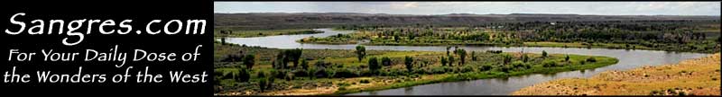
Teton Wilderness

At 585,468 acres, the Teton Wilderness is Wyoming's second largest wilderness. The Teton Wilderness straddles the Continental Divide with the Washakie Wilderness to the east, Yellowstone National Park to the north, Grand Teton National Park to the west and the Gros Ventre Wilderness and Mt. Leidy Highlands to the south. West of the Continental Divide, the wilderness is dominated by sagebrush hillsides, large grassy meadows, and lodgepole pine timbered ridges with elevations ranging from a low of about 7,500' to a high of 9,675'. The drainages here all feed west into the Snake and Columbia River watersheds. East of the Divide, the wilderness sports high alpine plateaus broken by ridges and large meadows with elevations ranging from a low of about 8,000' to a high at Yount's Peak of 12,165'. The streams here drain into the Yellowstone River, and eventually the Missouri and Mississippi Rivers.
The Teton Wilderness is home to the famous Two Ocean Creek, a creek which flows downhill to Two Ocean Pass and then separates in two, with Atlantic Creek flowing to the Atlantic and Pacific Creek to the Pacific. This point of separation is where you'll find the Parting of the Waters National Natural Landmark.
There's about 450 miles of trails in this popular wilderness. About half the visitors come to hunt or fish. Elk, deer, moose, bighorn sheep, grizzly bears, mountain lions, bison, and grey wolves are among the larger wildlife in the forest.
This wilderness can see snowfall on any day of the year, although a hot summer's day will see temperatures in the 80's. Daily temperature fluctuations can easily reach 40 to 50 degrees. The trails are usually clear of snow by late June but that snow starts coming back in September.

Teton Wilderness area map
Washakie Wilderness - Gros Ventre Wilderness - North Absaroka Wilderness
Grand Teton National Park - Yellowstone National Park - Buffalo Bill State Park
Centennial Scenic Byway - Buffalo Bill Cody Scenic Byway
