 |
|---|
Hunting and Fishing on
|
|
|
 |
Garfield County State Wildlife Areas
Fravert Reservoir Garfield Creek Parachute Ponds Piceance Roaring Fork West Bank West Rifle Creek Garfield County State Fish Units Crystal River Glenwood Springs Rifle Falls |
|
Fravert Reservoir RESTRICTIONS: Discharging firearms prohibited. _____________________________________________Garfield Creek Go 2 miles southwest of New Castle on CR 312 to Garfield Creek Road, turn and go 1 mile south. Parachute Ponds RESTRICTIONS: Float tubes allowed only for fishing; No camping, fires or swimming allowed. _____________________________________________Piceance Several units, all along Piceance Creek Road and reached from Meeker. Roaring Fork RESTRICTIONS: No camping, fires or shooting of firearms allowed. _____________________________________________West Bank Go south from Glenwood Springs on Highway 82, turn right at mile marker 5 on CR 154. West Rifle Creek Go north of Rifle for 4 miles on Highway 13 to Highway 325, turn right and go 6 miles to CR 252. Turn onto CR 252 and go 1 mile northwest. |
|
State Fish Units |
|
Crystal River Go 1 mile south of Carbondale on Highway 33. Glenwood Springs Go 2.2 miles north of Glenwood Springs along Mitchell Creek. Rifle Falls Go 15 miles north of Rifle on Highway 325 |
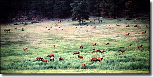 Elk in a meadow |
|
|
Garfield County Related Pages
Colorado Trust Lands & Wildlife Areas - GMU Map (.pdf)
State Trust Lands FAQ - Big Game Seasons (.pdf) Garfield County - The Colorado Fishing Story Colorado Pages
Towns & Places - Scenic Byways - State Parks - BLM Sites - History & Heritage Ski & Snowboard Areas - Photo Galleries - Colorado Mountains - Scenic Railroads Unique Natural Features - Wilderness Areas - Outdoor Sports & Recreation Colorado's National Forests - National Wildlife Refuges - Colorado's National Parks |

|
| Index - Arizona - Colorado - Idaho - Montana - Nevada - New Mexico - Utah - Wyoming National Forests - National Parks - Scenic Byways - Ski & Snowboard Areas - BLM Sites Wilderness Areas - National Wildlife Refuges - National Trails - Rural Life Advertise With Us - About This Site - Privacy Policy |
| Photos courtesy of Sangres.com, CCA ShareAlike 3.0 License. All text Copyright © by Sangres.com. All rights reserved. |