 |
|---|
Hunting and Fishing on
|
|
|
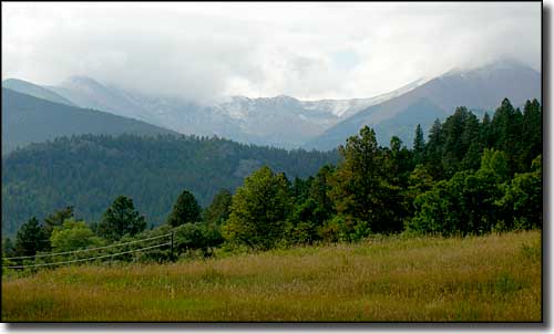 Late summer weather |
|
Fremont County State Trust Lands Badger Creek - GMU 57/58 Box Canyon - GMU 86 Cody Park - GMU 69 Cottonwood Ridge - GMU 581 Deer Haven - GMU 581 Dirty Gulch - GMU 58 Fernleaf Gulch - GMU 58 Florence- GMU 69 Grape Creek - GMU 69 McCoy Gulch - GMU 86 Newlin Creek - GMU 69 Parkdale - GMU 58 Pinnacle Rock - GMU 58/69 Sand Gulch #1 - GMU 58 Sand Gulch #2 - GMU 57
Sand Gulch #3 - GMU 58 Sand Gulch #4 - GMU 58 Short Creek Baldy - GMU 86 Stoney Face Mountain - GMU 58 Table Mountain - GMU 59 Tallahassee Road - GMU 59 Texas Creek #1 - GMU 58 Texas Creek #2 - GMU 58 Turkey Gulch - GMU 691 West Bear Gulch - GMU 69 Waugh Mountain - GMU 57/58 Fremont County State Wildlife Areas Beaver Creek Brush Hollow Treat/Ogden |
|
Badger Creek Lower Unit: From Cotopaxi go 21 miles north on Cty. Rd. 12, then west 1 mile on BLM road. Upper Unit: from Hartsel, go south 1.75 miles on Hwy. 9 to CR 53. Follow CR 53 for 22 miles to property. Box Canyon Take US 50 east for 2 miles from Salida to CR 49 (Bear Creek Road, FSR 101). Turn and go south 4 miles to FSR 101A, follow that to the end of the road. From there access is to the east, by foot and horseback only, across about 1 mile of National Forest to the western boundary of the property. Deer Haven From Canon City go west on US 50 to Highway 9, then go 9 miles north to CR 11, turn right and go 5.2 miles on CR 11 to Deer Haven Road, turn right and go 0.8 miles to Thompson Mountain Road. Turn right and go 0.7 miles to end. Dirty Gulch From Cotopaxi go 5.5 miles north on CR 12 Fernleaf Gulch Go north of Cotopaxi 1.5 miles on CR 12 to BLM Sand Gulch Road, turn east and go 3 miles to northwest corner of property. Florence From Canon City take Hwy. 67 southeast 13 miles to CR 15, which goes west to Florence Picnic Area, adjacent to property. Short Creek Baldy From Cotopaxi go west on US 50 for 6 miles to Kerr Gulch Road, go southwest about 5 miles to property. Stoney Face Mountain From Cotopaxi go 17 miles north on CR 12. Timber activity may be present. Table Mountain Go 8 miles east of Canon City on US 50 to Highway 67. Turn and go north on Highway 67 for 3 miles to CR 123, then go east on CR 123 for 1/4 mile to CR 132. Follow CR 132 for 9 miles to Beaver Creek State Wildlife Area. Access from upper parking area on the south and the east sides of property. Cody Park This tract is divided into 2 parcels. Tract 1: from Westcliffe, at Hwys. 69 & 96, go north on Hwy. 69 for 2.5 miles to CR 215, then go north 6.25 miles to southwest corner of property. Tract 2: From Hwy. 50 and 4th St. in Canon City go south on 4th St. 2 miles until street turns into CR 143. Go 10.3 miles south on CR 143 to BLM 6227. Go northwest on BLM 6227 for 4 miles to Grape Creek. The next 7 miles is across the BLM by foot or horseback only Grape Creek From Canon City at US 50 and 1st Street, go south on 1st Street for 1 mile to CR 3. Go west on CR 3 for 5.2 miles to Temple Canyon City Park. Go south 1/2 mile through park to northeast corner of property. Continue through property along Grape Creek and 1.7 miles along Grape Creek through BLM to Pine Gulch. Walk west up Pine Gulch 1.2 miles to property. McCoy Gulch From Cotopaxi go 4 miles south on CR 1-A to CR 37 to BLM land. Go east across BLM land to west boundary. Newlin Creek From Florence go south on Highway 67 for 4.5 miles to Newlin Creek Road. Go west on Newlin Creek Road 1 mile to northwest corner of section. Parkdale On US 50, 3 miles west of Parkdale Pinnacle Rock From Canon City go 15 miles west on US 50 to Salt Lick BLM area. Then go 1/2 mile south through BLM to northeast corner of property. Parking at Five Points recreation site. Sand Gulch #1 From US 50 in Howard, go north on CR 7 about 1/4 mile, then go east on CR 45 about 1/2 mile to Sand Gulch. At Sand Gulch turn and go north about 3/4 miles to property. Sand Gulch #2 From Arkansas River and Badger Creek, go north about 2.5 miles following closed BLM road. From BLM road closure, foot or horseback only. Sand Gulch #3 Go north from Cotopaxi on CR 12 about 4 miles to CR 157A, then turn and go west on CR 157A about 3/4 miles to BLM Falls Gulch/Falls Gulch Mountain Road. Go south, then west on BLM Falls Gulch/Falls Gulch Mountain Road about 3 miles. From end of road, property is 1 mile west on foot or horseback. Sand Gulch #4 Go north from Cotopaxi on CR 12 about 15 miles to Jack Hall BLM Road, then turn and go west on BLM road to designated parking area. Property is to the south and west about 4 miles. West Bear Gulch In Canon City at 1st St. and US 50 go south to CR 277. Go south on CR 277 for 11 miles (past USFS campground 2 miles) to BLM road, then northwest 2.5 miles to east boundary. Cottonwood Ridge From Canon City go west on US 50 for 12 miles, turn north on Hwy. 9 and go 6 miles. Turn west at Gate, go 0.8 mile to property. Tallahassee Road From Canon City go 12 miles west on US 50, then go 9 miles north on Highway 9 to CR 2. Take CR 2 west 3 miles to the property. Texas Creek #1 At Texas Creek on US 50, go north on CR 27 (Texas Creek Gulch) about 2.5 miles to 217A Road. Continue northwest on 217A for 1 mile to northeast corner of the property. Texas Creek #2 From Texas Creek #1 State Trust Lands, continue north on 217A for 5 miles. Texas Creek #2 is 1/2 mile west through BLM land, there's no access road to property. Turkey Gulch Take Highway 69 for 5 miles south of Texas Creek, then go 2 miles east on CR 28. Go 1 mile south on foot or horseback across BLM land to reach property. Waugh Mountain Go west from Canon City on US 50 for 12 miles, then turn north on Highway 9 and go 9 miles. Take CR 2 west for 15 miles. Foot access through BLM land on the east and south sides. Use BLM parking area. |
| State Wildlife Areas |
|
Beaver Creek From Canon City go 8 miles east on US 50 to Highway 67, then 9 miles north to CR 132 to property. Alternate route: From Skaguay Dam downstream 12 miles on trail to Beaver Creek. Brush Hollow From Penrose go 2 miles west on CR 123, then 2 miles north to property. Treat/Ogden Go west of Coaldale on US 50 for 2 miles to CR 45, then turn north and go 1.5 miles. Check the signs for public access. |
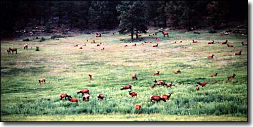 Elk in a meadow |
|
< |
Fremont County Related Pages
Fremont County - Canon City - Florence - Colorado Trust Lands & Wildlife Areas
State Trust Lands FAQ - Big Game Seasons (.pdf) - GMU Map (.pdf) The Colorado Fishing Story Colorado Pages
Towns & Places - Scenic Byways - State Parks - BLM Sites - History & Heritage Ski & Snowboard Areas - Photo Galleries - Colorado Mountains - Scenic Railroads Unique Natural Features - Wilderness Areas - Outdoor Sports & Recreation Colorado's National Forests - National Wildlife Refuges - Colorado's National Parks |

|
| Index - Arizona - Colorado - Idaho - Montana - Nevada - New Mexico - Utah - Wyoming National Forests - National Parks - Scenic Byways - Ski & Snowboard Areas - BLM Sites Wilderness Areas - National Wildlife Refuges - National Trails - Rural Life Advertise With Us - About This Site - Privacy Policy |
| Photos courtesy of Sangres.com, CCA ShareAlike 3.0 License. All text Copyright © by Sangres.com. All rights reserved. |