|
Alpine Loop - Lake City
This 65 mile loop linking Lake City, Ouray and Silverton is a high altitude ride on mostly dirt roads and includes traversing Cinnamon and Engineer Passes, both over 12,000 feet.
Argentine Pass - Arapaho-Roosevelt National Forest
Trail leading to 13,132 foot Argentine Pass for expert mountain bikers only. From Keystone take Montezuma Road 4.5 miles to Peru Gulch Trailhead. Follow Peru Gulch Trail for about 6 miles, then follow signs to Argentine Pass. Very rough, very steep terrain.
Bear Lake Road - Rocky Mountain National Park
This heavy use road for intermediate level bikers climbs 10 miles (and 1500 feet) to Bear Lake. Wildlife viewing, scenic overlooks.
Cherry Creek Bikeways - Cherry Creek SRA
This 8 mile network of trails around Cherry Creek Reservoir is very popular among joggers as well as bikers. Bike rental is available nearby.
Colorado State Forest - Gould
Colorado's only state forest also sports 112 miles of gravel and dirt roads making up a bike trail system. Mountains, lakes, forest, backcountry scenery.
Colorado Trail - Kassler
This trail passes through public and private lands, mostly at or near timberline, on various terrains. Contact the Colorado Trail Foundation for more details.
Crested Butte Trails - Crested Butte
With over 50 designated routes accomodating every skill level, this is a major mountain biking mecca of Colorado.
Dolores River Canyon - Dove Creek
26 mile marked route on an abandoned jeep trail. Immediately south of Dove Creek turn east and follow the Public Lands Access signs to river and parking areas. As several river crossings are necessary, call BLM Dolores Hot Line at 970-882-7600 for flow information before attempting this trip.
Ft. Collins Tour de Fort - Ft. Collins
56 miles of designated bikeways, trails, lanes, and routes, some exclusively for bikes. Contact the Ft. Collins Chamber of Commerce for a pocket guide to the system.
Garfield Trail - San Isabel National Forest
This scenic trail for the beginning mountain biker follows an abandoned spur of the Denver and Rio Grande Western RR. The grade rises at a steady 4% for the duration of the 3.8 mile trail which deadends at private property just east of Cree Creek.
Glenwood Canyon Bike Path - White River National Forest
This trail begins at the vapor cave east of the Hot Springs Pool in Glenwood Springs. The trail follows an old frontage road and crosses I-70 via a steep, short pathway. A short gravel switchback drops the trail to the Colorado River. When complete, the trail will extend the length of the canyon, some 20 miles.
Great Parks South Bicycle Route - Steamboat Springs
This 665 mile route begins in Steamboat Springs and winds through Rocky Mountain National Park, Georgetown, Montrose and Durango, crossing numerous mountain passes and wide valleys (parks) along the way. For more information contact: Bikecentennial, PO Box 8308, Missoula, MT 59807.
Hahn's Peak Lake/Nipple Peak Loop - Routt National Forest
This trail may require technical riding skills as it features steep climbs and descents on rocky, sandy soils. Follow FR 487 to TR 1156, ride west about 3 miles to TR 1147. Continue on TR 1147 to Summit Creek Guard Station and beyond, back to FR 129 and Hahn's Peak Lake turnoff. 21 miles roundtrip.
Hoosier Pass - Breckenridge
Follow State Route 9 on switchbacked, sometimes rough pavement for an elevation gain of 1900 feet in 11 miles as you climb to the summit of Hoosier Pass in the Arapaho-Roosevelt National Forest.
Kannah Creek Trail - Grand Mesa National Forest
This 11.8 mile trail follows Kannah Creek from the forest boundary to Carson Lake, passing several maller lakes among the aspens and spruces.
Kokopelli's Trail - Fruita
The first leg in the Colorado Plateau Mountain Bike Trail System. This 128 mile trip to Moab, Utah, winds through desert canyons and sagebrush prairies along the Colorado River. Segment difficulties range from easy to strenuous.
Manitou Park Bike Trail - Pike National Forest
From Woodland Park go north on State Route 67 for 6 miles to the South Meadows Campground. Park outside the campground entrance. This popular trail runs for 2 miles along State Route 67 and offers views of the Manitou Park area.
Maroon Creek Road - Aspen
Head north out of Aspen on State Route 82 for 1 mile, then turn left onto Maroon Creek Road. This heavy use route climbs 1000 feet in 9 miles to end at Maroon Lake with views of Pyramid Peak (14,018 feet) and the Maroon Bells.
Mesa Verde Loop - Mesa Verde National Park
This bike tour starts at the park entrance with a steady climb for 4 miles to the Far View Visitor Center. There are 2 routes available from here with spectacular views and access to Anasazi sites. Check at the entrance station for more details, some areas are seasonally accessible.
Peaks Trail - Frisco
This 9 mile route connects Frisco and Breckenridge along the Tenmile Range.The trailhead in Frisco is at the intersection of I-70 and Main Street. Proceed south and turn right onto Rainbow Lake Road. The trail leads on past the lake and eventually into the Breckenridge Ski Area.
Rim Rock Drive - Colorado National Monument
This 35 mile loop travels along Rim Rock Drive through the monument and then continues along State Route 340 to Grand Junction and back. Smooth pavement, excellent touring route, 2,300 feet in elevation gain.
Rollins Pass - East Portal
This route follows an abandoned railroad bed from East Portal 15 miles to the summit of 11,671 foot Rollins Pass. Spectacular views.
Schofield Pass - Marble
Very strenuous 30 mile trail from Marble to Crested Butte over 10,707 foot pass via narrow, rough and often dangerous roads. Heavy snowpack until late spring.
Tabeguache Trail - Olathe
This route travels 142 miles through canyons, mesas and highlands of the Uncompahgre Plateau. Extension of the Colorado Plateau Mountain Bike Trail System. Difficulty ranges from easy to advanced. Many 4x4 roads provide access to shorter segments of the trail.
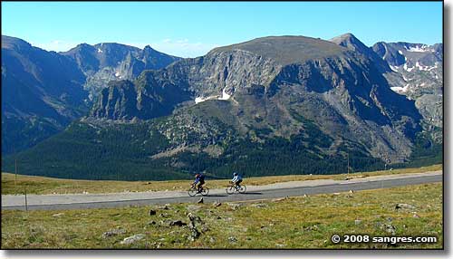
Trail Ridge Road - Rocky Mountain National Park
This very strenuous trip of 48 miles is recommended for experienced high altitude bikers only. The road climbs to alpine tundra and travels along the Continental Divide. Scenic pullouts and overlooks, Alpine Visitor Center near the top.
Transamerica Bicycle Trail - Walden
Part of a 4,300 mile trail that begins in Astoria, Oregon and ends in York, Virginia. Colorado section starts at state line on State Route 125 and goes through Kremmling, Dillon, Pueblo, Ordway, and leaves the state along State Route 96 near Towner.
Winter Park Mountain Bike Trail System - Winter Park
500 miles of designated trails, eight major loop arteries, thousands of backcountry roads, this is what makes the Winter Park area a haven for bikers. Contact the active local group Winter Park FATS for more information.
|