 |
Daniels County, Montana |
|
Daniels County is in northeastern Montana with Saskatchewan to the north. Daniels County was formed in 1920 and contains 1,426 square miles of land and 1 square mile of water. The county seat is Scobey. 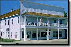
In the early 1900's, a prominent local rancher named Mansfield Daniels built the original settlement of Scobey with a post office, implement dealership, saloon, blacksmith shop, hotel and general store. He also built himself a mansion with more than 20 rooms. In 1912, a branch of the Great Northern Railway was built in the area, only it missed the settlement of Scobey by about 1.5 miles (that way the local railroad siding would be built on land owned by the railroad and the subsequent townsite could be platted and sold by the railroad). And, of course, all the local businesses bought lots and moved to New Scobey. The same thing happened with Flaxville, only Flaxville changed its name in the process (it was formerly known as either Boyer or Orville). A third local settlement was named Peerless (after Peerless Beer) but it hasn't done as well over the years since it, too, was moved in 1926 to be on the train tracks. |
| Fast Facts about Daniels County, Montana |
|
Resident Racial Breakdown:
White Non-Hispanic: 94.1% Native American: 5.7% Other: 0.2% Types of Jobs: Private Sector, wages or salary: 52% Government Sector: 20% Unincorporated, Self-Employed: 26% Homemaker, Unpaid: 2% Population Density: 1 Person per Square Mile 2011 Cost of Living Index for Daniels County: 81.3
2009 Estimates: Population: 1,703 Males: 834 Females: 869 Median Resident Age: 47.0 Years Estimated Median Household Income: $35, Estimated Median Home Value: $78,750 Major Industries: Agriculture, Educational Services, Health Care, Lodging & Food Services, Telecommunications, Construction, Government, Repair & Maintenance, Building Materials, Postal Service |
|
|
 |
| Index - Arizona - Colorado - Idaho - Montana - Nevada - New Mexico - Utah - Wyoming National Forests - National Parks - Scenic Byways - Ski & Snowboard Areas - BLM Sites Wilderness Areas - National Wildlife Refuges - National Trails - Rural Life Advertise With Us - About This Site - Privacy Policy |
|
Text Copyright © by Sangres.com. All rights reserved. |