 |
Pryor, Montana |
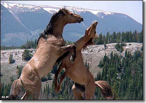 In the Pryor Mountains Wild Horse Territory |
|
Pryor is a Census Designated Place on the Crow Indian Reservation on the western side of Big Horn County. The town is located north of the Pryor Mountains near Chief Plenty Coups State Park. The area was named in honor of Nathaniel Hale Pryor, one of the members of the Lewis & Clark Expedition of 1804-1806. |
| Fast Facts about Pryor, Montana |
|
Pryor, Big Horn County, MT 59066
Elevation: 4,062' Latitude: 45.4156°N Longitude: 108.5415°W Resident Racial Breakdown: White Non-Hispanic: 9.5% Hispanic: 10.8% Native American: 76.0% Two or More Races: 3.7% Education: High School or Higher: 73.2% Bachelor's Degree or Higher: 17.3% Graduate or Professional Degree: 5.7%
2009 Estimates: Population: 632 Males: 326 Females: 306 Median Resident Age: 26.0 Years Estimated Median Household Income: $30,000 Estimated Median Home Value: $108,800 Population Density: 16 People per Square Mile 2011 Cost of Living Index for Pryor: 85.0 Major Industries: Educational Services, Government, Construction, Agriculture, Health Care, Transportation Services, Social Services, Waste Management Services, Retail Services Unemployed (March 2011): 13.3% |
|
|
 |
| Index - Arizona - Colorado - Idaho - Montana - Nevada - New Mexico - Utah - Wyoming National Forests - National Parks - Scenic Byways - Ski & Snowboard Areas - BLM Sites Wilderness Areas - National Wildlife Refuges - National Trails - Rural Life Advertise With Us - About This Site - Privacy Policy |
| Photo of wild horses courtesy of the Bureau of Land Management. Text Copyright © by Sangres.com. All rights reserved. |