 |
Teton Scenic Byway |
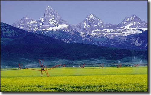 The Grand Tetons from the west |
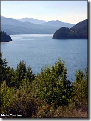
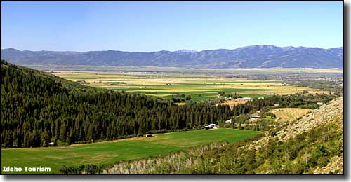
Teton Scenic Byway is a gorgeous 69-mile drive through the Teton Valley on the west side of the Grand Teton Mountains. This is a historic area where mountain men and fur trappers in the early 1800's gathered and had their famous rendezvous several times. The first documented non-native to enter the valley was John Colter, formerly a member of the Lewis & Clark Expedition. After Colter came the first French fur trappers, then brigades of American and British/Canadian trappers. The Teton Scenic Byway starts north from Swan Valley and ends in Ashton. Along the way you'll pass through Victor, Driggs and Tetonia, old mining, logging, ranching and farming towns. For this whole drive you'll probably be mesmerized by the views of the Grand Tetons to the east. This is the quiet side of the mountains, mostly agricultural these days, but if you're going to the internationally renowned Grand Targhee Ski and Summer Resort, you're driving this road. The biggest agricultural crop in the area: Idaho's famous potatoes. Swan Valley is just downstream of Palisades Reservoir (pictured in the photo to the right). The road passes through Caribou-Targhee National Forest and crosses Pine Creek Pass before dropping down into Victor. At Victor is where Idaho 31 ends, and you'll turn north on Idaho Highway 33 to just beyond Tetonia, where you'll turn north again on Idaho Highway 32 to complete the route to Ashton. At Ashton is the junction with the Mesa Falls Scenic Byway, leading past two of the very few waterfalls in the American West that are still left free-flowing these days. When the Grand Tetons were first pushed up out of the Earth some 10 million years ago, they were one big chunk of granite. Over the years since, that one big rock has been whittled away by the forces of ice, wind and water to create the spectacular mountains we see today. Some of the best access to the Jedediah Smith and Winegar Hole Wildernesses is from the Idaho side in this area. While a lot of the West was built on a foundation of coal, the only coal mine in Idaho used to be at a place called Sam, near Horsehoe Creek. The coal was discovered in 1901 and by 1920, more than 30,000 tons of low-ash bituminous coal had been shipped from the area. However, 1930 saw the mine close because the coal started to cost too much to ship and too much to dig (another casualty of the Great Depression). At Victor was a mine that shipped high-grade limestone to the sugar beet mill in Idaho Falls for use in the purification of sugar. Part of the old railroad bed that carried that limestone is now a paved 7-mile hiking and biking trail between Victor and Driggs. Driggs is the site of several rendezvous in the 1830's where mountain men, fur trappers, Nez Perce and Shoshone Indians and St. Louis-based traders got together to trade goods, share stories, party and relax a bit. Mormon settlers first arrived in 1889 and started building the town we see today. Victor was established by the Mormons only a short time later. |
 Teton Valley 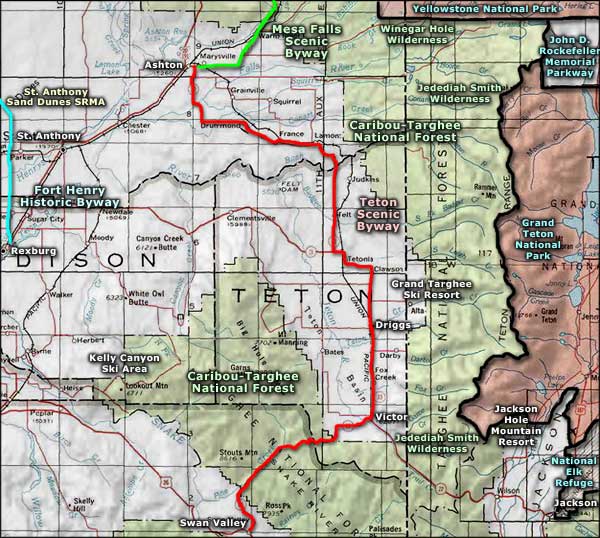 Teton Scenic Byway area map |
|
|
Teton Scenic Byway Related Pages
Jackson Hole Ski Resortt - Grand Targhee Ski Resort - Kelly Canyon Ski Area
Mesa Falls Scenic Byway - Grand Teton National Park - Yellowstone National Park Winegar Hole Wilderness - Jedediah Smith Wilderness - National Elk Refuge Caribou-Targhee National Forest - John D. Rockefeller Memorial Parkway Fort Henry Historic Byway - St. Anthony Sand Dunes SRMA Idaho Pages |
 |
| Index - Arizona - Colorado - Idaho - Montana - Nevada - New Mexico - Utah - Wyoming National Forests - National Parks - Scenic Byways - Ski & Snowboard Areas - BLM Sites Wilderness Areas - National Wildlife Refuges - National Trails - Rural Life Advertise With Us - About This Site - Privacy Policy |
| Photos courtesy of Idaho Tourism. Area map courtesy of National Geographic Topo! Text Copyright © by Sangres.com. All rights reserved. |