 |
Elk River Back Country Byway |
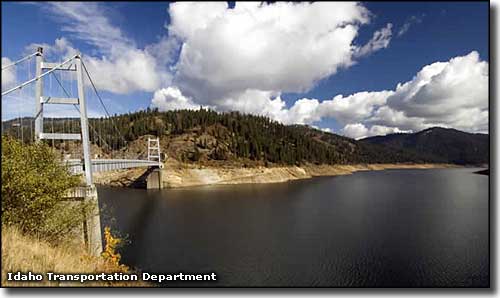 Dent Bridge across Dworshak Reservoir, Elk River Back Country Byway |
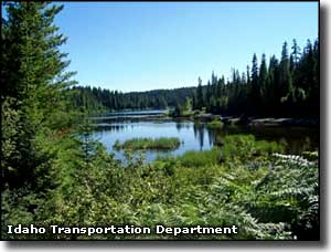
The Elk River Back Country Byway is a 57-mile, all natural and unpretentious route through the forests of north central Idaho. The northern terminus is in Bovill at the junction of State Highways 3 and 8, the southern terminus in Orofino at the junction of State Highway 7 and Wells Bench Road. The road from Bovill to Elk River is paved, then turns to gravel at Elk River. Wells Bench Road is paved from Orofino to one mile north of the Dent Bridge, then is gravel for the rest of the journey to Elk River. The route is open year-round but can be icy in the winter. From Bovill, you can turn east off of Idaho 38 onto Idaho 8 and travel to Elk River on pavement. This is a huge forested landscape with tantalizing views of the Clearwater Mountains on the horizon. This is wild and varied countryside with lots of wildlife. Once you get to Elk River make sure you check out the Elk River Historical Museum and get the full story as to how a hunting resort could become a bustling mill town and then return to its former status as a hunting resort. If you're here in the right season, you might want to see about the local huckleberry crop, too. Elk River was originally founded as a remote recreation (hunting and fishing) camp. Then the Potlatch Lumber Company bought 4,000 acres of timber in the area in 1909 and built the first electric-powered lumbermill in America in Elk River, turning the place into a mill town. Spring runoff on the Clearwater River was high enough to float logs downstream to the sawmills in Lewiston so timber was harvested year round and sent downstream only in that seasonal high flow. Eventually, a railroad line was extended from Bovill to Elk River and shipping could happen year-round. In 1910, Potlatch built an electric-powered sawmill in Elk River. And then a few years ago Potlatch abandoned the area and Elk River returned to being a quaint recreational community on the edge of virtual wilderness. Just outside Elk River is the Elk Creek Reservoir, built by Potlatch as a "millpond" back in 1910 to store logs for the new sawmill they were building in Elk River. These days the pond is famous for the quality of its fishery and for the number of bald eagles, swans, ospreys and river otters that frequent the area. Just outside Elk River in Perkins Cedar Grove is Idaho's largest tree. It's a western red cedar with a trunk 18 feet in diameter and 177 feet tall. The tree is estimated to be about 3,000 years old. This giant is on Forest Service property and surrounded by other old growth trees, most of which are at least 500 years old. Also just outside Elk River is Elk Creek Falls: a site where a cascade of three waterfalls drops over ancient lava walls. The original hunting community at Elk River was built around the waterfalls. From Elk River you'll be traveling on old logging roads. You'll pass by the trailhead leading to Elk Creek Falls and then come to the Dent Bridge across Dworshak Reservoir. The bridge is named for Katherine and Charles Dent, folks who homesteaded on the North Fork of the Clearwater back in 1895. The Army Corps of Engineers designed and built the bridge, starting in December, 1969. When they were done several years later, the 1,550-foot-long bridge was judged one of the 18 most beautiful man-made structures in America. After crossing the Dent Bridge you'll be on the paved Wells Bench county road. Between Whiskey Creek and Orofino you'll be driving across Wells Bench itself, an area of farmsteads and ranchettes scattered among the benches and stands of timber (although the closer you get to Orofino, the less timber you'll see). This is wild and woolly Idaho at its best. |
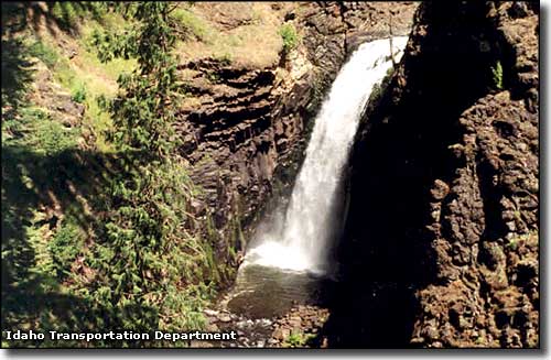 Elk Creek Falls 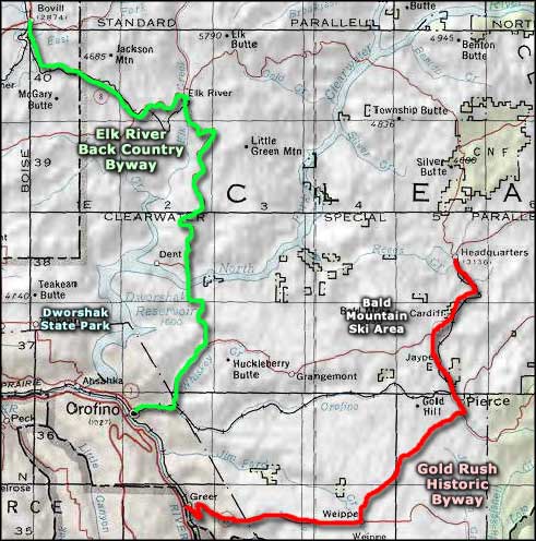 Elk River Back Country Byway area map |
|
|
 |
| Index - Arizona - Colorado - Idaho - Montana - Nevada - New Mexico - Utah - Wyoming National Forests - National Parks - Scenic Byways - Ski & Snowboard Areas - BLM Sites Wilderness Areas - National Wildlife Refuges - National Trails - Rural Life Advertise With Us - About This Site - Privacy Policy |
| Photos courtesy of the Idaho Transportation Department. Area map courtesy of National Geographic Topo! Text Copyright © by Sangres.com. All rights reserved. |