
Scenic Highway of Legends
Trinidad to Stonewall

The Sangre de Cristo Mountains from the Scenic Highway of Legends, near Stonewall
Click on the photo for a larger version
State Highway 12, the Scenic Highway of Legends ties Trinidad, Weston, Stonewall, Cuchara, La Veta, Walsenburg and Aguilar together with a ribbon of asphalt that journeys through some of the most beautiful mountain countryside in the world.
Beginning at the Colorado Welcome Center on the corner of Nevada and University, the Scenic Highway of Legends makes a few turns before exiting the City of Trinidad. Along the way you pass Central Park (site of the Trinidaddio Blues Festival every August), the Donnelly Gym of Trinidad High School (that gold domed building everyone asks about) and the old Mt. Carmel Church (now closed). Going west now, you go through Jansen and then up the hill and past two entrances to Trinidad Lake State Park.
There's another hill to climb and then descend (to the intersection by Cokedale) before crossing one final hill and entering the Purgatoire River Valley. Before Trinidad Lake was created, the Highway ran along the bottom of the river canyon through the towns of Piedmont, Sopris and St. Thomas before joining with the present route of the Highway near Long's Canyon.
The Purgatoire River was named many years ago, during the time when Spanish Conquistadors were exploring the area in their search for Cibola (the Seven Cities of Gold), around 1594. The legend says the leaders of the expedition argued and Juan Hermana killed Francisco Bonilla to assume full leadership of the group.
The priest who accompanied them refused to follow a murderer so he and part of the expedition left and returned south to Mexico. Hermana and the others forged ahead and continued searching. Some say they found gold near the Spanish Peaks and forced Native Americans to dig it out for them. In leaving the area, they killed all their Native American slaves and headed south over Cuchara Pass with their ill-gotten gold.
All versions of the legend say they were ambushed near the Purgatoire and wiped out to a man. Their bones and armour were found many years later along the river bank but no stash of gold has ever been found. Because they died without the benefit of last rites, they were said to be in Purgatory and the river was named "El Rio de Las Animas Perdidas en Purgatorio." The French changed that to "Purgatoire" and the English to "Picketwire."

Trinidad Lake Dam, Fisher's Peak in the background
Trinidad Lake is a man-made lake completed in 1977 by the US Army Corps of Engineers. The 6,610-foot earthfill dam across the Purgatoire River was built for flood control, irrigation and recreation. The level of the lake rises and falls depending on irrigation usage. About 2,500 acres of State Park surround the (on average) 800-acre lake.
When the dam was built, five small communities were moved: Sopris, Sopris Plaza, Viola, Piedmont, and St. Thomas. Two miles below the dam is the final resting place of Horace Long, the first Anglo settler west of Trinidad. Also in the area of the lake were 48 Native American archaeological sites, mostly left by the Jicarilla Apache. While some of these sites are now under water and some are hidden in the surrounding bluffs, one area of thousand-year-old pre-Jicarilla stone rings is open to the public at the top of Carpios Ridge near the amphitheater.

An aerial view of Trinidad Lake,
looking west up the Purgatoire River Valley towards the Sangre de Cristo's
The Highway continues on and passes by Cokedale, rated the "Best Preserved Coal Mining Camp" in Colorado. Cokedale was founded in 1907 by the American Smelting and Refining Company and reached a population of 1500 by 1909 with 350 coking ovens in operation. Cokedale's refinery facilities serviced two mines at Cokedale and a third at Boncarbo, seven miles away.
Cokedale was one of many mining towns developed in the early 1900's. Several companies operated mines in both Las Animas and Huerfano Counties, generating over 60 percent of Colorado's coal output. Also dotting the counties were coke plants. The purpose of making coke from coal is to remove all moisture and as much sulphur and phosphorus as possible, leaving only fixed carbon and ash. Using coke in the process of smelting iron was preferred as it burned with intense heat, was free of foreign substances and was porous enough to allow good circulation of air in the blast furnaces.
In 1947, the coke ovens were shut down and the Company (ASARCO) left town. The residents of Cokedale were offered their homes for $100 per room and $50 per lot. Because a lot of people took them up on this offer, quite a bit of the original town is still standing, providing us with a good view of a turn-of-the-century mining camp. However, most of the houses that weren't bought immediately were bulldozed so they wouldn't be taxable (so much of our history has been destroyed for this reason). The residents who stayed, organized and incorporated Cokedale in 1948. The old coke ovens can be seen right beside the road as you go by town. Cokedale was placed on the National Historic Register in 1984.
Just outside of Cokedale can be seen the big mountains of coal slag: impurities washed and cooked out of the coal and discarded. If you are around on a cold day you can see steam rising from the piles of slag, as if a great fire were burning within.

The coke ovens of Cokedale
Next are Madrid and Valdez, two almost abandoned coal camps (the old mine works are across the river) before coming to Segundo, a small town full of wonderful architecture. It is said that a Mr. Chrysler was born and raised in Valdez. He lived in Valdez long enough to build his first automobile there in a little shop.

Looking west near Lorencito Canyon
In 1862, Felipe Baca returned to the Purgatoire River Valley from Mora, New Mexico, with his own and 12 other families to settle in the area. Some of these families travelled upriver and settled in family-oriented villages called plazas. A plaza usually formed a square for protection in case of Indian attack. South of Highway 12 sits the Cordova Chapel, built in 1871 as part of Cordova Plaza. As the Cordova family's private chapel, it was still in use in the 1940's.
Even earlier, when the Spanish Conquistadors were exploring northern New Mexico and southern Colorado, they often left behind a few of their group, usually with a priest, to settle in an area and form a colony. When Mexico gained her freedom from Spain, the priests were called back to Spain and these colonies were left without official representatives of the church to guide them. In this vacuum, Los Hermanos Penitentes came into being to keep the faith alive and to protect the community. Their rituals include acts of penance and self-flagellation, and focus on the crucifixion and death of Jesus Christ, culminating in a Passion Play during the week before Easter. Through the years, the Penitente membership has declined but they are still somewhat active in this area.
Old Segundo, or Los Varros, was one of several plazas that sprang up along the Purgatoire in the 1860's. Segundo, the mining town, was built in the early 1900's. At that time, Segundo was the largest coal processing plant west of Chicago with 800 coking ovens. The Colorado and Wyoming Railroad reached Segundo in 1901 and built its operating headquarters there. A five-stall roundhouse was built and every day, trains from Segundo went west to Tercio and east to Trinidad.
Colorado Fuel & Iron (CF&I) opened a number of coal mines in the valley in the early 1900's. Some of the names were Primero, Segundo, Tercio, Cuatro, Quinto and Sexto, along with Sopris, Cornell and Valdez. Primero and the Frederick Mine at Valdez were the major producers. The Cuatro mine operated for only 4 years before it blew up, killing 19 miners. Quinto operated for only 2 years and the records don't show any coal being shipped from either Sexto or Cornell.
It was at the old town of Primero that a high school was started in 1917, and CF& I began transporting students to school by train. About 120 students rode to school every day. Occasionally, the boys would roll boulders onto the tracks the night before so the morning train would be late for school. One of these mornings, CF& I owner John D. Rockefeller, Jr. was aboard the school train. It was never late again.

Weston
Continuing west you'll come to Weston. At the east edge of Weston you'll see the first signs for the aptly named Bosque del Oso State Wildlife Area, 33,000+/- acres of prime wildlife habitat. Several miles west of town there's another well marked entrance. A friend who knows the area well told me to be careful in there: there's a lot of bears. There's a lot of elk and deer, too.
Weston was originally named Los Sisneros, after Juan Sisneros, a rancher who settled here in the 1880's. Other settlers tried to name it La Junta (meaning "the junction") as the North and South Forks of the Purgatoire meet here, but that name was already taken. In 1889 the first post office was established and the town was named Weston, after Bert Weston, the town's first postmaster. The Rocky Mountain Timber Company logged the area heavily in the late 1800's and early 1900's and used Weston as a supply base.
Before the Spanish and Americans came, the Scenic Highway of Legends area was home to several Native American tribes, including the Mohuache Ute and the Jicarilla Apache who lived in the foothills and mountains. The Comanche and Kiowa hunted and camped along the upper Purgatoire River for years and the Cheyenne and Arapaho roamed the high plains east of Trinidad and Walsenburg.
The Maxwell (Beaubien and Miranda) Land Grant was a gift to 2 French heroes of the Mexican War of Independence, from the government of Mexico. Miranda had no heirs. Beaubien's son died in Taos during the Taos Uprising in 1847 and the Land Grant passed on to his daughter Luz, who was married to Kit Carson's friend, Lucien Maxwell, hence Maxwell Land Grant. In the treaties signed at the end of the Mexican War, the validity of the Land Grant was recognized and Lucien Maxwell found himself owner of 1.7 million acres (most of Colfax County, New Mexico and a big piece of Las Animas County in Colorado). However, as late as the 1880's, the Ute and Apache felt this land was their homeland and these newcomers were squatters, but their claims were never recognized.
The Ute were bitter enemies of the Cheyenne and war cries were occasionally heard, even after the Purgatoire and Cuchara Valleys had been homesteaded by newcomers. Among the natives it was also customary that at certain times of the year, all attacks would cease so that peaceful trading could take place.
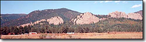
The Sangre de Cristo Mountains are easily seen from Weston. They get their name from the Spanish explorers who first noticed that the peaks turn red with the first rays of the morning sun, naming them the "Blood of Christ" Mountains. There's a story about an old prospector who found a very rich gold mine somewhere near timberline on those mountains. He came to town once a year, each time with a nugget so big he could buy all his supplies for another year at the one time. He told someone once that he used the reddish color of the morning on the mountain snow to find his mine. After his death many searched for the mine but no one has ever found the "Gold where the Snow turns to Blood."

The view of the Sangres from just east of Stonewall
The highway continues west to Vigil and Stonewall. Vigil was first settled by Juan Vigil and his family in the early 1860's. Juan served as the County Assessor and County Sheriff for many years. The Town of Vigil was incorporated and had a post office from 1890 to the early 1920's. Just off the highway is the "House on the Bridge." The bridge was originally part of the road leading from Trinidad to Stonewall but the road was rerouted in 1918. State Senator Joseph E. Martinez was a half-brother to Charles Vigil, the property owner, and he built a small house on the bridge. Some time later Charles' brother Marcus had the house rebuilt as it is now.
Just west of Vigil Plaza sits the San Isidro Church, dating back to the 1870's and named for the patron saint of farmers.
Weddings were big events in the early days. The plans began with a letter to the prospective bride's parents from the prospective groom's parents, asking permission for the son to marry the daughter. In many cases the parents selected the bride and she might not even know the man she was to marry. The groom's parents bought the bride's wedding dress and delivered it to her at the engagement ceremony, on the day before the wedding. Sometimes she didn't even see the dress until the morning of her wedding day.
And even then, some weddings still didn't happen as planned. There's the story of the young man courting 2 girls at the same time. He finally decided on one, and requested that the mother of the other be one of the cooks at the wedding. This mother happily agreed. Knowing every wild herb that grew in the area, and how to use them, this woman searched out just the right herb - tasteless and odorless - and ground it into a fine powder. As she was cooking for the wedding, she sprinkled this herb on the groom's food. The last thing the wedding guests saw of the groom was him being carried out of the reception.
The New Elk Mine was one of the more recent coal mines developed, its' first portal opened in 1946 under the name Apache Prospect. CF& I bought the property in 1951 and renamed it the Allen Mine. In 1977, CF& I opened the Maxwell Mine about 2 miles east of the Allen Mine. These two coal mines were the only active mines in the area when they were bought by Basin Resources Inc. in 1991. The Allen Mine was renamed the New Elk Mine and the Maxwell Mine became the Golden Eagle Mine. In those last few years, mining was only carried on in the Golden Eagle, with the New Elk site being used as a processing plant for washing and shipping the coal. The large pipe and conveyor belt that crosses over Highway 12 at Milepost 29.4 carried the slag and refuse to a dump site in a canyon north of the highway. Annual production at the Golden Eagle was 1.2 million tons of coal when operations ceased.
The Dakota Wall to the north of Stonewall
You'll know when you reach Stonewall because it is named for the incredible Dakota Sandstone walls that traverse the area from south to north. The rock wall rises up to 250 feet above Stonewall. The sandstone was originally formed at the bottom of an ocean and was tilted upright some 65 million years ago when the Ancestral Rockies were first pushed up during the Laramide Orogeny.
In the 1880's, Maxwell Grant representatives claimed that the Stonewall Valley was part of the Grant and that the settlers there must pay for their homesteads or leave. Contending that the Grant representatives had moved the Grant boundary markers far to the north, the settlers vowed not to give in without a fight. Richard Russell, one of Stonewall's earliest settlers, went to meet with the Maxwell representatives at the Stonewall Hotel under a white flag. Realizing that he was a leader of the settlers, one of the Grant gunmen shot and killed him before he reached the door of the Hotel. The armed settlers surrounded the Hotel but the Grant men escaped through a coal chute and got away. Despite pleas from the settlers, the US Government upheld the Grant claims and the settlers ended up paying for property they had lived on for many years.
South of Stonewall are Torres, Tercio and Vermejo Park Ranch, probably the largest contiguous ranch property in America. Tercio was a coal camp built by CF& I in 1901. Tercio Mine featured 6 portals and 600 coking ovens. Mining ceased in 1915 when production exceeded 1.5 million tons per year. Today, only the company store remains standing at the townsite.

Looking west near Torres, south of Stonewall
One of the oldest myths of the Stonewall Valley is the tale of the "lonesome water." It is said that many years ago, when the Earth was young, water flowing down from the Sangre de Cristo's fell in love with a little green valley that lay in the cool blue shadow of the great stone wall. It refused to leave the valley, sinking deep into the ground and loitering where the roots of the wild roses were tucked into the soil. To this day, the water only comes up in clear little springs among the rocky ridges. They say it has a peppermint flavor and looks like green ice, but once a person has tasted it, he is forever a lover of the Stonewall Valley.
>